|
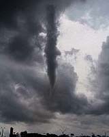
West Lafayette IN (SPX) Mar 01, 2006 A Purdue University researcher and his team have used improved satellite imaging and powerful computer modeling to more accurately forecast the likelihood and intensity of storms and tornados. The key to the new weather prediction model is its more precise simulation of the amount of moisture surface vegetation is releasing into the upper atmosphere to affect the weather conditions, said Dev Niyogi (pronounced Dave Knee-yoo-gee), an assistant professor of agronomy and earth and atmospheric sciences. Niyogi said that current weather prediction models represent vegetation at a very simplistic level. "How well we are able to represent one leaf in a weather forecast model can be a key to predicting thunderstorms," he said. "In fact, the amount of moisture plants are emitting during photosynthesis may be considered the local trigger that trips fronts into violent weather." Niyogi and his team based the research on two days in the 2002 International H20 Project, a large-scale, six-week field experiment that was a consolidated, coordinated effort funded by the National Science Foundation consisting of multiple researchers gathering huge datasets of weather information. Niyogi, who also is the Indiana state climatologist, was a participating researcher in the International H20 Project. The research data were gathered on May 24-25, 2002, when a front moved southeast and met a cold front over western Texas, in what meteorologists call a "triple point." This condition often indicates severe thunderstorms and the potential for severe weather. Using the baseline data from this real weather event, Niyogi said the researchers "set out to assess how including the improved land-vegetation processes," along with winds, convection, soil moisture and other factors, would affect the weather prediction. "The idea is to take the baseline data and the different simulations from Naval Research Laboratory's Coupled Ocean/Atmosphere Mesoscale Prediction System for systematic improvements in soil, plant photosynthesis and soil moisture models to forecast a May 25 severe weather event," he said. The simulations also took advantage of the finer scale data from satellite imagery of smaller and smaller plots of land. "We've gone from being able to observe and analyze 100 square kilometer plots in the past down to 10 kilometers and even 1 kilometer," Niyogi said. "The clarity of the picture we're getting is analogous to a digital photograph becoming clearer as the pixels get smaller." Niyogi said the actual weather on May 25 was "severe," with several thunderstorms occurring along a front. "The standard 'default' forecast did a reasonable job of predicting the storms, but the storms developed more slowly than predicted," he said. "The intensity and coverage of the storm were less than predicted, however." When the photosynthesis vegetation model was added, Niyogi said there was a more accurate prediction of temperature and humidity, as well as the intensity, location and timing of the storms. Thus, the major finding in the research is the extent to which plants releasing moisture into the atmosphere can become a major factor in triggering storms in the upper atmosphere. This finding holds the promise of more accurate prediction of storms and tornadoes in the future. "Plants emit much more moisture into the atmosphere in a shorter time than does bare ground or even the lakes," Niyogi said. "Plant photosynthesis works like a jogger perspiring because the plant loses water as it makes food." Niyogi's team broke the plants down into types � such as mixed forest, grassland, shrubland, savanna and irrigated crops � because different plants release different amounts of moisture into the atmosphere at varying rates, in what's called "photosynthesis-based transpiration." The research was published in the January issue of the Monthly Weather Review, a publication of the American Meteorological Society. Niyogi said future research will attempt "to enhance the land-vegetation model, which will improve forecasting the location, timing and intensity of storms, thunderstorms and tornados. We also can improve our ability to include satellite datasets, remote sensing and satellite mapping into weather forecast models as well as making the vegetation modeling more realistic." Other members of the research team were Teddy R. Holt from the Marine Meteorology Division, Naval Research Laboratory, Monterey, Calif.; Fei Chen, Kevin Manning and Margaret A. LeMone from the National Center for Atmospheric Research in Boulder, Colo.; and Aneela Qureshi, from the Department of Marine, Earth, and Atmospheric Sciences at North Carolina State University. The research was funded by the Office of Naval Research, National Science Foundation and NASA. Community Email This Article Comment On This Article Related Links Purdue University Weather News at TerraDaily.com
 Paris (SPX) Feb 26, 2006
The directors general of ESA and EUMETSAT signed an updated agreement last week to launch the Meteorological Operational satellite, or MetOp, Europe�s first polar-orbiting satellite dedicated to weather and climate monitoring. |
|
| The content herein, unless otherwise known to be public domain, are Copyright 1995-2006 - SpaceDaily.AFP and UPI Wire Stories are copyright Agence France-Presse and United Press International. ESA PortalReports are copyright European Space Agency. All NASA sourced material is public domain. Additionalcopyrights may apply in whole or part to other bona fide parties. Advertising does not imply endorsement,agreement or approval of any opinions, statements or information provided by SpaceDaily on any Web page published or hosted by SpaceDaily. Privacy Statement |