|
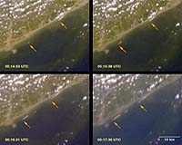
Pasadena CA (JPL) Jan 20, 2005 Newly released imagery from three NASA spaceborne instruments sheds valuable insights into the Indian Ocean tsunami that resulted from the magnitude 9 earthquake southwest of Sumatra on December 26. The images offer several unique views of portions of the affected region. The data are and will be used by scientists and government agencies to assist with disaster recovery, mitigate the effects of future natural hazards and increase our understanding of how and why tsunamis strike. The data were acquired by the Multi-angle Imaging SpectroRadiometer and the Advanced Spaceborne Thermal Emission and Reflection Radiometer instruments on NASA's Terra spacecraft, as well as from the Shuttle Radar Topography Mission. To access the new images available on the Web, visit: http://www.nasa.gov/vision/earth/lookingatearth/tsunami-images.html. The Multi-angle Imaging SpectroRadiometer imagery includes the only known animations produced by a remote sensing instrument to capture tsunami waves in motion as they make landfall. The image set and animations were collected December 26 as Terra passed over the eastern Indian coast about an hour and a half after the first waves hit shore. The first animation shows tsunami waves breaking along the shores of the Indian state of Andhra Pradesh, near the mouth of the Godavari River. Because the instrument's multiple cameras imaged the coast over several minutes and the waves were unusually large, the instrument captured unique time-lapse imagery of them. The resolution is 275 meters (900 feet). The still images show frames from four of the instrument's cameras, and span a period of about two and a half minutes. In the second animation, waves break further to the south, near the mouth of the Krishna River. The data indicate the location and timing of some of the waves, their angle relative to the shoreline and their speed, estimated from these data to be about 30 kilometers (19 miles) per hour. Together with measurements of ocean depth, these data can be used to refine models of how tsunamis originate and travel. Better understanding of how tsunamis interact with coastal areas is one factor needed to improve near-real-time forecasts of tsunami arrival times and effects, and to reduce damage from such waves in the future. Terra's Advanced Spaceborne Thermal Emission and Reflection Radiometer instrument acquired images of the area around Phuket on the Indian Ocean coast of Thailand on December 31. The pair of simulated natural color images shows a 27-kilometer (17-mile) stretch of coast north of the Phuket airport on December 31, along with an image acquired two years earlier. The changes along the coast are self-evident, clearly indicating the extent of vegetation stripped by the waves. The images are being used to create damage assessment maps for the U.S. Agency for International Development Office of Foreign Disaster Assistance. The resolution is 15 meters (49.2 feet). The separate image trio depicts these same before/after views and contrasts them with a third view created with Shuttle Radar Topography Mission data. Elevations below 10 meters (33 feet) are highlighted in red, and include most of the areas inundated by the tsunami, though offshore ocean depth variations, coastal landforms, distance from the coast and additional factors control the damage extent. Still, elevation measurements as provided by the Shuttle Radar Topography Mission, give a general indication of areas at risk, and can help planners better predict which areas of a region are in the most danger and help develop mitigation plans in the event of particular flood events. The Shuttle Radar Topography Mission has also produced a color-coded shaded relief map of the island nation of Sri Lanka, highlighting regions below 10 meters (33 feet) in elevation. The data were collected during the 11-day Space Shuttle mission in February 2000 and released publicly in July 2003. The low coastal elevations extend 5 to 10 kilometers (3.1 to 6.2 miles) inland and are especially vulnerable to flooding associated with storm surges, rising sea level and tsunami. The Multi-angle Imaging SpectroRadiometer was built and is managed by NASA's Jet Propulsion Laboratory, Pasadena, Calif. Japan's Ministry of Economy, Trade and Industry built the Advanced Spaceborne Thermal Emission and Reflection Radiometer. NASA's Goddard Space Flight Center, Greenbelt, Md., manages the Terra satellite. The Shuttle Radar Topography Mission is a collaboration of NASA, the National Geospatial-Intelligence Agency and the German and Italian space agencies. Community Email This Article Comment On This Article Related Links Advanced Spaceborne Thermal Emission and Reflection Radiometer at NASA Multi-angle Imaging SpectroRadiometer at NASA Shuttle Radar Topography Mission at NASA SpaceDaily Search SpaceDaily Subscribe To SpaceDaily Express Tectonic Science and News
 Sydney (AFP) Dec 12, 2005
Thousands of tonnes of ash are continuing to spew from a volcano in Vanuatu, but officials said Monday the activity on the South Pacific nation was not likely to result in a major deadly eruption. |
|
| The content herein, unless otherwise known to be public domain, are Copyright 1995-2006 - SpaceDaily.AFP and UPI Wire Stories are copyright Agence France-Presse and United Press International. ESA PortalReports are copyright European Space Agency. All NASA sourced material is public domain. Additionalcopyrights may apply in whole or part to other bona fide parties. Advertising does not imply endorsement,agreement or approval of any opinions, statements or information provided by SpaceDaily on any Web page published or hosted by SpaceDaily. Privacy Statement |