|
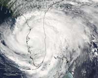
Paris (AFP) Apr 20, 2005 British scientists say they have devised the first accurate tool to predict the severity of the US hurricane season, an innovation that could help save lives and cut costs for the insurance industry. The American hurricane season technically runs from June 1 to November 30. But Mark Saunders and Adam Lea of Britain's Benfield Hazard Research Centre looked at US weather records from 1950 to 2003 and found that 86 percent of hurricane strikes - and 96 percent of the worst ones - occurred after August Their most important discovery was that, in July, anomalies in regional wind patterns give a clear pointer as to whether the hurricane season from August onwards will be severe or calm. Tested on historical data of winds and hurricane costs from 1950-2003, the model was 74 percent accurate in predicting whether a season in any year would be above average or below average in severity. It was also spot-on in its first real-life run last year, predicting accurately that the 2004 season would be above average in harshness. "We forecast high activity and this was the case," Saunders told AFP. "If companies had bought extra insurance cover on the basis of this forecast, they would have reduced their losses." Hurricanes that make landfall in the United States mainly target Florida, the eastern seaboard and Gulf coast. They rank as the biggest natural disaster in the US, accounting for eight out of the 10 costliest catastrophes to hit the country. The annual average damage bill for the continental US between 1950 and 2004 is put at 5.6 billion dollars. The range goes from zero, in 10 of those years, to more than 44 billion dollars, in the 1992 season. The computer model is based on anomalies in well-known wind patterns at heights ranging from 750 to 7,500 metres (2,400 to 24,000 feet) over North America, the North Atlantic and the tropical East Pacific. Once these unusual pressure systems are established in July, they tend to remain throughout the hurricane season, acting like rudders that steer a storm - either nudging it towards land or blocking it over the sea, where it blows itself out harmlessly. "One (such rudder) is the Bermudan high pressure system," said Saunders. "If that is stronger than normal in July, the wind anomalies associated with that steer hurricanes towards US landfall. If it's weaker than normal, then the opposite would happen, the winds would tend to steer hurricanes away from striking the US." The model, based on July wind data provided by the US National Oceanic and Atmospheric Administration (NOAA), does not seek to predict when and where a hurricane will strike. Instead, it is a predictor as to how much damage the August-November season will inflict when compared with the historical average. Even so, says Saunders, "Anyone involved who suffers financial risk and uncertainty from the hurricane season as a whole could benefit from this work. I think it's the forecast with the best precision." This year's prediction will be posted on August 4 on www.tropicalstormrisk.com, a website that gives forecasts for hurricanes and typhoons. Saunders said the next step would be to fine-tune the model to see how individual parts of the United States might be hit by a bad hurricane season and explore the possibility of a similar predictor for Asia. Another area of research is the effects of climate change on hurricane severity, he said. Global warming, inflicted by carbon pollution from fossil fuels, is deemed likely to make storms more frequent and more destructive, although there are many unknowns in this field. The study appears on Thursday in Nature, the British weekly science journal. Community Email This Article Comment On This Article Related Links SpaceDaily Search SpaceDaily Subscribe To SpaceDaily Express Weather News at TerraDaily.com
 London UK (SPX) Dec 23, 2005
This week's launch of MSG-2 will ensure that satellite images continue to be available to European weather forecasters well into the next decade. It also marks a new chapter in a long-term space experiment measuring the available energy that drives the weather as a whole, and helping to establish how much the Earth is heating up. |
|
| The content herein, unless otherwise known to be public domain, are Copyright 1995-2006 - SpaceDaily.AFP and UPI Wire Stories are copyright Agence France-Presse and United Press International. ESA PortalReports are copyright European Space Agency. All NASA sourced material is public domain. Additionalcopyrights may apply in whole or part to other bona fide parties. Advertising does not imply endorsement,agreement or approval of any opinions, statements or information provided by SpaceDaily on any Web page published or hosted by SpaceDaily. Privacy Statement |