|
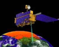
Moffett Field - Apr 07, 2003 NASA scientists are developing a new planning and scheduling system for Earth observation satellites (EOS), designed to acquire and integrate data from multiple complementary Earth-sensing instruments, enabling them to build complex models of the Earth's ecosystem. Developed by a team of scientists at NASA Ames Research Center located in California's Silicon Valley and NASA Goddard Space Flight Center, Greenbelt, Md., the new software is being designed to coordinate the observations made by entire fleets of satellites, which currently is done manually by each satellite's individual mission operation center. "The scientific need for multiple sources of Earth science data in order to explain complex phenomena will require coordination in instrument scheduling and operations," explained Robert Morris, a computer scientist at NASA Ames who serves as the project's principal investigator. Morris heads a seven-member team of experts in planning technology, systems integration and engineering, Earth science and mission operations. "We propose to develop both a set of technology concepts and a prototype system based on these concepts that will address problems in coordinated scheduling, while acknowledging the realities of present-day mission design concepts," Morris added. Entitled "Planning and Scheduling of Coordinated Science Observations," the project recently received funding from NASA's Office of Earth Science under the Advanced Information Systems Technology (AIST) Program. The project was one of 21 new investigations in information systems technology development that received over $20 million from the AIST Program. NASA Ames' project received nearly $900,000. Through the AIST Program, NASA invests in research and development of new and innovative information technologies. The research supports and enhances NASA's Earth science enterprise and applications objectives as part of the agency's mission to understand and protect our home planet. "The Committee on Earth Observation Satellites estimates that international space agencies are planning more than 80 Earth-observing missions over the next 15 years," Morris noted in the introduction to "An Integrated Architecture for Science Observation Scheduling for Fleets of Earth Observing Spacecraft," a research paper he co-authored with Jennifer Dungan, Jeremy Frank, Lina Khatib and David E. Smith. "The missions will carry over 200 different instruments, providing measurements of many environmental change parameters." Morris and his team of NASA scientists hope to improve communication between the various mission planners by using automated scheduling technology to coordinate satellite imaging and manage the increasing volume of scientific data produced during the missions. Over the course of the two-year project, the science team will design algorithms that can be used to integrate new observation requests with an EOS constellation's existing operations plan. Upon completion of that phase, the team will integrate science observation scheduling technology developed at NASA Ames with the Automated Mission Planning and Scheduling (AMPS) system developed at NASA Goddard for use with EOS missions involving either single or multiple satellites. Finally, the team will develop a technology plan for coordinated science planning for multiple missions and an enhanced automated tool for coordinated science planning of future EOS missions. The tool would be integrated with data collected by ground stations, to improve mission management and communication. When the project is completed, Morris and the other members of the science team hope that the new planning and scheduling system will help Earth scientists develop better models of the Earth's ecosystem. "The goal is that through this sort of automation and increased coordination, the ultimate outcome will be more useful scientific data," Morris said. Community Email This Article Comment On This Article Related Links NASA Ames Research Center SpaceDaily Search SpaceDaily Subscribe To SpaceDaily Express Earth Observation News - Suppiliers, Technology and Application
 New York NY (SPX) Jan 11, 2006
The importance of remotely sensed data and technologies to support natural disasters has prompted attention and action in Washington. New initiatives and legislation authorizing appropriations to the remote sensing industry will be discussed at Strategic Research Institute's U.S. Commercial Remote Sensing Industry conference, scheduled for February 9-10, 2006 in Washington D.C. |
|
| The content herein, unless otherwise known to be public domain, are Copyright 1995-2006 - SpaceDaily.AFP and UPI Wire Stories are copyright Agence France-Presse and United Press International. ESA PortalReports are copyright European Space Agency. All NASA sourced material is public domain. Additionalcopyrights may apply in whole or part to other bona fide parties. Advertising does not imply endorsement,agreement or approval of any opinions, statements or information provided by SpaceDaily on any Web page published or hosted by SpaceDaily. Privacy Statement |