|
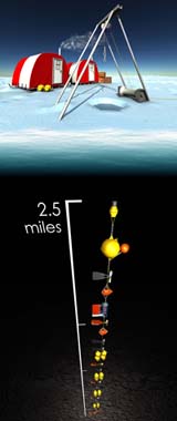
Corvallis OR (SPX) Jun 21, 2004 Long before a Hollywood blockbuster about catastrophic climate change packed cinema multiplexes this spring, researchers at the top of the world, supported by the National Science Foundation (NSF), were using an array of scientific tools to build a comprehensive scientific picture of environmental change in the Arctic and what it may mean for the rest of the globe. Led by oceanographer James Morison, of the University of Washington, NSF- supported scientists from Oregon State University, as well as others supported by the National Oceanic and Atmospheric Administration (NOAA), the Naval Post-graduate School, and the Japan Marine Science and Technology Center, are conducting an array of experiments at the North Pole to understand this little-known, but extremely important region. The Polar regions, scientists believe, will sound the earliest warnings that changes in global climate are underway and, in recent years, the Arctic has experienced a well-documented warming trend. Whether this change is permanent or part of a cycle and what the potential effects of a warmer Arctic Ocean could be are questions the team hopes to answer. NSF, which funds the North Pole Environmental Observatory (NPEO) through its Office of Polar Programs, is making available video of the researchers working at the Pole, interviews with key NPEO scientists at the Pole and an animation of a mooring string scientists use to place instruments there. The mooring collects and measures ice thickness and movement, water temperature and salinity, and the speed and direction of underwater polar currents for a year. In keeping with the global scale of the project, the mooring string stretches more than 4.2 kilometers (2.6 miles) from the bottom of the Arctic Ocean to within feet of the constantly shifting polar ice pack. That's longer than Mt. Rainier is high. In addition to the mooring, scientists with Morison's group are drilling through ice often more than 3.6 meters (12 feet) thick to install NOAA buoys that measure air temperatures through the ice cover. They also are imbedding automated sensors into the sea ice to send the detectors on a trek thousands of meters long, from the North Pole to Greenland, to measure heat fluctuations in the upper ocean. Subtle changes in these temperatures can mean large variations in the thickness of ice that covers the ocean. Finally, Morison and colleague Kelly Falkner, of Oregon State University, fly a small aircraft along a line several thousand kilometers long from which they take seawater samples from 1,000 meters below the surface for chemical analysis. Community Email This Article Comment On This Article Related Links Oregon State University SpaceDaily Search SpaceDaily Subscribe To SpaceDaily Express Earth Observation News - Suppiliers, Technology and Application
 New York NY (SPX) Jan 11, 2006
The importance of remotely sensed data and technologies to support natural disasters has prompted attention and action in Washington. New initiatives and legislation authorizing appropriations to the remote sensing industry will be discussed at Strategic Research Institute's U.S. Commercial Remote Sensing Industry conference, scheduled for February 9-10, 2006 in Washington D.C. |
|
| The content herein, unless otherwise known to be public domain, are Copyright 1995-2006 - SpaceDaily.AFP and UPI Wire Stories are copyright Agence France-Presse and United Press International. ESA PortalReports are copyright European Space Agency. All NASA sourced material is public domain. Additionalcopyrights may apply in whole or part to other bona fide parties. Advertising does not imply endorsement,agreement or approval of any opinions, statements or information provided by SpaceDaily on any Web page published or hosted by SpaceDaily. Privacy Statement |