|
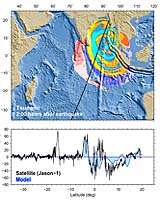
Silver Spring MD (SPX) Jan 13, 2005 After reviewing data from four Earth-orbiting radar satellites, NOAA scientists Wednesday announced they were able to measure the height of the devastating tsunami that erupted in the Indian Ocean. The ability to make depth surveys from space may lead to improvements in the models that forecast the hazardous effects of tsunamis. NOAA is an agency of the U.S. Department of Commerce. The height goes down over time as the wave spreads over the ocean and the energy is expended on shore. At 2 hours after the quake, it was 60 cm (about 2 feet) high. By 3 hours 15 minutes after the quake, that dropped to around 40 cm (about 16 inches) high. By 8 hours 50 minutes after the quake, the wave spread over most of the Indian Ocean and was quite small in most areas - 5 to 10 cm (2 to 4 inches) - about the limit of the satellite resolution. However, the wave was still large enough after all that elapsed time that it was still bouncing around in the Bay of Bengal still appears about 25 cm high (10 inches) as measured by the satellites. Several days after the Indian Ocean tsunami, scientists from NOAA's Laboratory for Satellite Altimetry in Silver Spring, Md., examined data from the four spacecraft - the TOPEX/Poseidon and Jason, operated jointly by NASA and the French space agency, CNES; the European Space Agency's Envisat and the U.S. Navy's Geosat Follow-On. "By chance, these satellites were in the right place at the right time," said Walter H.F. Smith, a geophysicist at the NOAA LSA, which routinely monitors sea-level variations from space using radar measurements taken by several satellites. The measurements are used to make simple charts of unexplored ocean basins, and to forecast the intensification of hurricanes, the onset of an El Ni�o, and other weather and climate events. Upon further investigation of satellite data, NOAA researchers were able to detect the Indian Ocean tsunami in profiles of sea level along the satellites' flight paths by comparing the sea level seen on Dec. 26, 2004, with the sea level measurements the satellites picked up a few days, or weeks, earlier. Also, U.S. and French teams, working in parallel with data from the joint NASA/French Space Agency's Jason and TOPEX/Poseidon, independently confirmed the satellites' measurements of the height of the tsunami waves. "These observations are unique and of tremendous value for testing and improving tsunami computer models and developing future tsunami early warning systems," said Lee-Lueng Fu, of NASA's Jet Propulsion Laboratory in Pasadena, Calif. Smith emphasized that LSA does not get the satellite data until several hours after a tsunami has developed - too late to be used as a real-time forecast. "Right now, this technique is not a first line of defense in tsunami hazard monitoring and warnings, but it gives scientists a window to tsunami activity in the deep and in remote parts of an ocean basin, too far away from coastal tide gauges and other instruments that could detect it," Smith added. Smith said NOAA researchers proposed that the best application of satellite data to improve tsunami hazard forecasts would be a reconnaissance mapping of the ocean floor from space. "The detailed shape of the sea bed, all across the ocean basin, determines the focusing - or diffusion - of tsunami energy barreling toward the coast." At NOAA's Pacific Marine Environmental Laboratory in Seattle, scientists have developed a computer model, showing how the tsunami moved across the Indian Ocean. Combined with the data from LSA, the PMEL model showed the changing sea levels along the flight paths of the four satellites, which crossed the ocean basin after the earthquake. PMEL scientists apply the tsunami computer model to provide hazard assessments for communities at risk, and develop a real-time forecast system for NOAA's Tsunami Warning Centers. Vasily Titov, an oceanographer at PMEL, said the satellite observations would be used in ongoing research to improve the understanding of how tsunamis move across the ocean. Community Email This Article Comment On This Article Related Links NOAA NOAA's Satellite and Information Services NOAA Laboratory for Satellite Altimetry NOAA Satellites SpaceDaily Search SpaceDaily Subscribe To SpaceDaily Express Earth Observation News - Suppiliers, Technology and Application
 New York NY (SPX) Jan 11, 2006
The importance of remotely sensed data and technologies to support natural disasters has prompted attention and action in Washington. New initiatives and legislation authorizing appropriations to the remote sensing industry will be discussed at Strategic Research Institute's U.S. Commercial Remote Sensing Industry conference, scheduled for February 9-10, 2006 in Washington D.C. |
|
| The content herein, unless otherwise known to be public domain, are Copyright 1995-2006 - SpaceDaily.AFP and UPI Wire Stories are copyright Agence France-Presse and United Press International. ESA PortalReports are copyright European Space Agency. All NASA sourced material is public domain. Additionalcopyrights may apply in whole or part to other bona fide parties. Advertising does not imply endorsement,agreement or approval of any opinions, statements or information provided by SpaceDaily on any Web page published or hosted by SpaceDaily. Privacy Statement |