 |
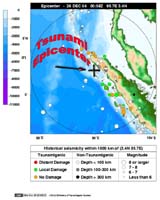
Honolulu, Hawaii (SPX) Dec 27, 2004 NOAA scientists acted quickly when a warning was issued about the powerful undersea earthquake in the Indian Ocean that triggered a devastating tsunami. The NOAA Pacific Tsunami Warning Center in Hawaii issued an information bulletin at 8:14 p.m. EST Saturday, indicating that a magnitude 8.0 earthquake had occurred off the west coast of Northern Sumatra. Because the earthquake, reported to be one of the strongest in the world in the past 40 years, occurred in the Indian Ocean, not the Pacific, there was no threat of a tsunami to the West Coast of North America. Within a few hours of learning of the tsunamis that killed thousands in Indonesia Saturday night, Vasily Titov, associate director of the Tsunami Inundation Mapping Efforts, or TIME, at the NOAA Pacific Marine Environmental Laboratory in Seattle, Wash., and his counterpart in Japan had created preliminary model estimates of the event. A tsunami is a series of ocean waves generated by any rapid large-scale disturbance of the sea water. Most tsunamis are generated by earthquakes, but they may also be caused by volcanic eruptions, landslides, undersea slumps or meteor impacts. In 1963 the term "tsunami" was adopted internationally to describe this natural phenomenon. A Japanese word, it is the combination of the characters tsu (harbor) and nami (wave). They are often mistakenly called "tidal waves." However, the tides have nothing to do with the formation of tsunamis. The waves radiate outward in all directions from the disturbance and can propagate across entire ocean basins. For example, in 1960, an earthquake in Chile caused a tsunami that swept across the Pacific to Japan. Tsunami waves are distinguished from ordinary ocean waves by their great length between peaks, often exceeding 100 miles in the deep ocean, and by the long amount of time between these peaks, ranging from five minutes to an hour. While they cannot be seen from the air, or felt aboard an ocean-going ship, tsunamis can cause as great a loss of life and property as their other natural disaster cousins - tornadoes and hurricanes. The speed at which tsunamis travel depends on the ocean depth. A tsunami can exceed 500 mph in the deep ocean but slows to 20 or 30 mph in the shallow water near land. In less than 24 hours, a tsunami can cross the entire Pacific Ocean. A tsunami warning system for the West Coast of the U.S. recently was awarded the Gold Medal, the Department of Commerce's highest award. "As with any natural hazard, education and warnings are essential," said Eddie N. Bernard, director of the NOAA Pacific Marine Environmental Laboratory and first chairman of the Tsunami Hazard Mitigation program, a multi-state, multi-agency effort. "If people know what a tsunami is, what causes it, and what to do in case it happens, fewer lives may be lost." Persons caught in the path of a tsunami are at extreme risk from being crushed or struck by debris, or drowning. Children and the elderly are particularly at risk, as they often have less mobility, strength and endurance. Residents are advised to seek higher ground or travel inland to get out of the tsunami's path. Part of NOAA's mission is to understand changes in the Earth's environment and to provide public safety services. The NOAA National Weather Service operates two tsunamis warning centers - one each in Hawaii and Alaska. The West Coast/Alaska Tsunami Warning Center was established in 1967 as a result of the 1964 9.2 earthquake in Alaska that left 132 dead - 122 of those deaths have been attributed to the tsunami that was generated. The Pacific Tsunami Warning Center was established in 1948, following the 1946 tsunami in Hawaii that left more than 150 people dead. In December 2001, the center was renamed the Richard H. Hagemeyer Pacific Tsunami Warning Center in honor of the late director of the NOAA National Weather Service Pacific Region who ran the U.S. Tsunami Program for 19 years. To increase awareness about tsunamis, the NOAA National Weather Service began the voluntary TsunamiReady Community program that helps areas prepare for such events. To date, there are 10 communities in Alaska, Washington, Oregon and California that have met the TsunamiReady criteria. The Coastal Ocean Program at the NOAA Ocean Service supported development of two tools for dealing with Tsunami Hazards: model-based inundation maps and the deep ocean warning system. Inundation maps, developed by the NOAA Pacific Marine Environmental Laboratory, identify areas that are susceptible to flooding before a tsunami occurs and are used to develop evacuation and land-use plans. The NOAA Ocean Service also operates an extensive network of tide gauges used by the warning centers to determine if a tsunami has been generated. NOAA is dedicated to enhancing economic security and national safety through the prediction and research of weather and climate-related events and providing environmental stewardship of the nation's coastal and marine resources. NOAA is part of the U.S. Department of Commerce. Community Email This Article Comment On This Article Related Links NOAA Pacific Tsunami Warning Center Bulletins and Map NOAA Tsunami Page Deep-ocean Assessment and Reporting of Tsunamis (DART) NOAA Water Level Observation Network NOAA and Tsunamis SpaceDaily Search SpaceDaily Subscribe To SpaceDaily Express Tectonic Science and News
 Sydney (AFP) Dec 12, 2005
Thousands of tonnes of ash are continuing to spew from a volcano in Vanuatu, but officials said Monday the activity on the South Pacific nation was not likely to result in a major deadly eruption. |
|
| The content herein, unless otherwise known to be public domain, are Copyright 1995-2006 - SpaceDaily.AFP and UPI Wire Stories are copyright Agence France-Presse and United Press International. ESA PortalReports are copyright European Space Agency. All NASA sourced material is public domain. Additionalcopyrights may apply in whole or part to other bona fide parties. Advertising does not imply endorsement,agreement or approval of any opinions, statements or information provided by SpaceDaily on any Web page published or hosted by SpaceDaily. Privacy Statement |
