|
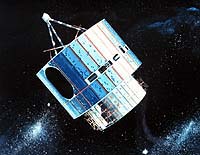
Washington - May 20, 2001 After a long and distinguished career spanning almost 24 years, one of the nation's workhorse satellites was boosted into higher orbit and removed from service, announced the Commerce Department's National Oceanic and Atmospheric Administration. GOES-2, launched from Cape Canaveral on June 16, 1977, was operational as an imaging satellite until 1993, when it stopped giving imagery of cloud conditions across the United States. At that time GOES-2 was deactivated, but left in its old orbit position. From May 1 to 5, 2001, NOAA performed de-orbit maneuvers designed to boost the satellite into super-synchronous orbit, about 186 miles (300 kilometers) above the geosynchronous altitude of 22,300 miles (35,680 kilometers). This maneuver made room for another geosynchronous satellite to be launched. Because there are many satellites in geosynchronous orbit at the 22,300 mile altitude, it is important to make room for new satellites. Even though GOES-2 went dark in 1993, it was still of use to people on the ground. In 1995, it was re-activated to broadcast the Pan-Pacific Education and Communication Experiments by Satellite program administered by the University of Hawaii. PEACESAT is a public service satellite telecommunications network that links educational institutions, regional organizations, and governments in the Pacific Islands region. GOES-2 was the second operational satellite in NOAA's Geostationary Operational Environmental Satellite system of 11 satellites to date. It outlived its expected three-year lifetime. The satellite, a cylinder 75 inches in diameter and 106 inches high, weighed 650 pounds. The sides of the cylinder were covered by 15,000 solar cells which, along with batteries, provided power for the satellite. The spacecraft was stabilized in space by spinning, much like a top, and rotated at 100 revolutions per minute. The principal instrument on board was the Visible Infrared Spin Scan Radiometer, which provided imagery of cloud conditions. The satellite had the capability to monitor extreme weather events (such as hurricanes and typhoons) continuously; relay meteorological data from over 10,000 surface locations into a central processing center for incorporation into numerical weather prediction models; and to perform facsimile transmission of processed images and weather maps to WEFAX field stations. In addition, a Space Environment Monitor to look at space weather, and a Data Collection System to gather data from buoys were onboard. The de-orbit maneuvers were executed from the Kokee Park Geophysical Observatory station in Hawaii by a team of NOAA and NASA personnel, in coordination with NOAA's Satellite Operations Control Center in Suitland, Md. Community Email This Article Comment On This Article Related Links NOAA's Geostationary Operational Environmental Satellite NOAA Satellites SpaceDaily Search SpaceDaily Subscribe To SpaceDaily Express Dirt, rocks and all the stuff we stand on firmly
 Real, Philippines (AFP) Nov 30, 2004
Rescuers were desperately searching for survivors Tuesday after floods and landslides unleashed by a tropical storm in the Philippines killed more than 300 people and left at least 150 others missing, many buried alive under tonnes of debris. |
|
|
|
|
|
|
|
|
|
|
|
|
|
| The content herein, unless otherwise known to be public domain, are Copyright 1995-2006 - SpaceDaily.AFP and UPI Wire Stories are copyright Agence France-Presse and United Press International. ESA PortalReports are copyright European Space Agency. All NASA sourced material is public domain. Additionalcopyrights may apply in whole or part to other bona fide parties. Advertising does not imply endorsement,agreement or approval of any opinions, statements or information provided by SpaceDaily on any Web page published or hosted by SpaceDaily. Privacy Statement |