|
Vandenberg AFB (SPX) May 10, 2005 Launch of NOAA's latest polar-orbiting satellite NOAA-N has been delayed until early Thursday morning due to high winds. The launch team at Vandenberg AFB will make another attempt at 1022 GMT (6:22am EDT; 3:22am PDT).
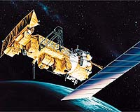
earlier related report NOAA-N is the 15th in a series of polar-orbiting satellites dating back to 1978. NOAA uses two satellites, a morning and afternoon satellite, to ensure every part of the Earth is observed at least twice every 12 hours. Severe weather is monitored and reported to the National Weather Service which broadcasts the findings to the global community. With the early warning, effects of catastrophic weather events can be minimized. NOAA-N also has instruments to support an international search-and-rescue program. The Search and Rescue Satellite-Aided Tracking System, called COPAS-SARSAT, transmits to ground stations the location of emergency beacons from ships, aircraft and people in distress around the world. The program, in place since 1982, has saved about 18,000 lives. NOAA-N is the first in a series of polar-orbiting satellites to be part of a joint cooperation project with the European Organisation for the Exploitation of Meteorological Satellites (EUMESTAT). NOAA-N is the latest in the Advanced TIROS-N (ATN) satellite series. All have been designed and built for the National Aeronautics and Space Administration (NASA) by Lockheed Martin since the first Television and Infrared Observational Satellite (TIROS) weather satellite launch in April 1960. NASA is managing the spacecraft's launch and the National Oceanic and Atmospheric Administration (NOAA) will operate the satellite once in space. Over many years of service, the TIROS satellites have earned the reputation as the workhorses of the Civil Space Earth-imaging inventory. "Our long-standing partnership with our NASA customer is a genuine source of pride for Lockheed Martin, and we look forward to the launch of NOAA-N," said Dan Hoffman, Lockheed Martin TIROS program director. "The Lockheed Martin team has been totally dedicated to providing NASA with a series of satellites that extend NOAA's ability to provide uninterrupted environmental data products to users." A constellation consists of two POES satellites circling the planet in nearly north-south orbits. As the Earth rotates, the entire globe, one swath at a time rolls into view of the satellites' instruments. The satellites provide measurements of reflected solar and radiated thermal energy from land, sea, clouds and the atmosphere in the visible and infrared spectrum, atmospheric soundings of temperature and humidity, measurements of global sea surface temperature, aerosol distribution data, ozone concentration data, soil moisture data, and measurements of orbital proton and electron flux. Additionally, POES satellites collect data from remote platforms, relay search and rescue data, and also provide direct broadcast of environmental data worldwide. Data from the spacecraft supports a broad range of environmental monitoring applications including weather analysis and forecasting, climate research and prediction, ocean dynamics research, volcanic eruption monitoring and forest fire detection. Together these data comprise irreplaceable inputs to the numerical weather forecast model and are vital to medium and long-range forecasting. Separately or in combination, the data are utilized to produce sea-surface temperature maps, ice condition charts, vegetation maps and other forecasting and management tools. The NOAA-N spacecraft is 13.75 feet long by 6.2 feet in diameter, and weighs 3130 pounds at liftoff. Its solar array has 180.6 square feet of surface area and generates 833 watts at a zero degree sun angle. NASA's Goddard Space Flight Center, in Greenbelt, MD, is responsible for the procurement, development, launch services, and verification of the spacecraft, instruments, and unique ground equipment. Following spacecraft launch, Goddard is responsible for satellite health and safety during a comprehensive on-orbit verification period that lasts 45 days. Following satellite checkout, NASA turns operational control of the satellite over to NOAA. NOAA will operate the satellite from the Satellite Operations Control Center along with the nation's other environmental satellites. The NOAA-N satellite will operate in a circular, near-polar orbit of 470 nautical miles above the Earth with an inclination angle of 98.73 degrees to the equator. Its orbital period - the time it takes to complete one orbit of the Earth - will be approximately 102.14 minutes. The NOAA-N orbit is Sun- synchronous, rotating eastward about the Earth's polar axis 0.968 degrees each day, approximately the same rate and direction as the Earth's average daily rotation about the Sun. The rotation keeps the satellite in a constant position with reference to the Sun for constant scene illumination throughout the year. Community Email This Article Comment On This Article Related Links NOAA-N Launch Page NOAA SpaceDaily Search SpaceDaily Subscribe To SpaceDaily Express Earth Observation News - Suppiliers, Technology and Application
 New York NY (SPX) Jan 11, 2006
The importance of remotely sensed data and technologies to support natural disasters has prompted attention and action in Washington. New initiatives and legislation authorizing appropriations to the remote sensing industry will be discussed at Strategic Research Institute's U.S. Commercial Remote Sensing Industry conference, scheduled for February 9-10, 2006 in Washington D.C. |
|
| The content herein, unless otherwise known to be public domain, are Copyright 1995-2006 - SpaceDaily.AFP and UPI Wire Stories are copyright Agence France-Presse and United Press International. ESA PortalReports are copyright European Space Agency. All NASA sourced material is public domain. Additionalcopyrights may apply in whole or part to other bona fide parties. Advertising does not imply endorsement,agreement or approval of any opinions, statements or information provided by SpaceDaily on any Web page published or hosted by SpaceDaily. Privacy Statement |