|
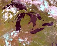
Greenbelt - Jun 27, 2002 The image is from NOAA-17, which was launched on June 24 from Vandenberg Air Force Base, Calif., and named NOAA-M before launch. The image shows cloud patterns over the Great Lakes area. Like other NOAA satellites, NOAA-17 will collect meteorological data and transmit the information to users around the world to enhance weather forecasting. In the United States, the data will be used primarily by NOAA's National Weather Service for its long-range weather and climate forecasts. NOAA-17 was built by Lockheed Martin Space Systems Co., Sunnyvale, Calif., and launched for NOAA under technical guidance and project management by NASA's Goddard Space Flight Center. NASA will turn operational control of the NOAA-17 spacecraft over to NOAA 21 days after launch. NASA's comprehensive on-orbit verification period is expected to last until approximately 45 days after launch. Community Email This Article Comment On This Article Related Links NOAA SpaceDaily Search SpaceDaily Subscribe To SpaceDaily Express Dirt, rocks and all the stuff we stand on firmly
 Real, Philippines (AFP) Nov 30, 2004
Rescuers were desperately searching for survivors Tuesday after floods and landslides unleashed by a tropical storm in the Philippines killed more than 300 people and left at least 150 others missing, many buried alive under tonnes of debris. |
|
| The content herein, unless otherwise known to be public domain, are Copyright 1995-2006 - SpaceDaily.AFP and UPI Wire Stories are copyright Agence France-Presse and United Press International. ESA PortalReports are copyright European Space Agency. All NASA sourced material is public domain. Additionalcopyrights may apply in whole or part to other bona fide parties. Advertising does not imply endorsement,agreement or approval of any opinions, statements or information provided by SpaceDaily on any Web page published or hosted by SpaceDaily. Privacy Statement |