|
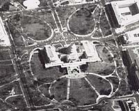
Bethesda - Oct 18, 2002 The National Imagery and Mapping Agency (NIMA) recently co- sponsored with the University of Maryland University College (UMUC) a Historical Imagery Declassification (HID) Conference. The event was held on Sept. 20, 2002, at the UMUC Inn and Conference Center in Adelphi, Md. NIMA is leading a U.S. Government effort to declassify and release to the public a variety of historical information about our nation's Intelligence Systems. The Agency's mechanism is the Historical Imagery Declassification (HID) Program. The HID Program has three goals: promote the spirit of open governance, demonstrate results of taxpayer investment in national security and ensure that researchers -- from environmentalists to historians -- have access to useful and unique sources of information. The HID Conference, "America's Eyes: What We Were Seeing," was the capstone of a NIMA-led effort with other Intelligence, Department of Defense and civil organizations to review and declassify Keyhole (KH) imagery from the KH-7 surveillance imaging system and KH-9 mapping system. It marked the official transfer of the original satellite imagery from NIMA to the National Archives and Records Administration (NARA), as stipulated by Executive Order (EO) 12951. Signed on February 22, 1995, the EO directs the release of certain scientific or environmentally useful imagery, consistent with national security, to the public and creates a research repository for the images and complimentary material. NIMA's Deputy Director Joanne O. Isham presented a film canister, representing declassified imagery to Dr. Michael J. Kurtz, Assistant Archivist for Records Services. She said, "The program's goal of promoting the spirit of open governance is in keeping with finest traditions of this great country." Dr. Gerald Heeger, president, University of Maryland, welcomed the attendees to the conference and to the University of Maryland. "In the use of technology in education, UMUC is a leader, just as NIMA is a leader in its use of technology. And, like NIMA, we think of ourselves as part of the defense community," he said pointing to an alumni group of more than 1,000,000 U.S. service men and women and 50 flag officers. The Honorable J. Robert Kerrey, President, New School University, gave the keynote address, and said of NIMA "Your work saves lives. It's that simple. Better decisions by policy makers�enable the power of the United States to be leveraged many times over." UMUC history professor John Newman called the images "a treasure trove" and commended NIMA for the great academic benefit they serve. "This kind of release assists the people, the historians, the scientists and the politicians to learn from mistakes and avoid making them in the future," said Newman, a 2002 Stanley Drazek Teaching Excellence Award recipient. A series of panel discussions concluded the event. The high-resolution KH-7 surveillance imaging satellite, flown from July 1963 to June 1967, monitored key targets such as ICBM complexes, radar systems, and hot spots around the globe. This system complemented the CORONA search system. Whereas the CORONA missions were dedicated to answering: "Is there something there?" this higher- resolution system assisted imagery analysts in watching that something, to learn more about it, identify it, and classify it. This system also provided the basis for producing large-scale maps of airfields, harbors, cities, and missile defense systems. The lower-resolution KH-9 mapping system was devoted exclusively to gathering information for mapmaking, and collected imagery from March 1973 to October 1980. Geodetic data, including precise geopositioning, elevation, and other information provided the DoD with accurate point locations for air, sea and ground operations. This system was also used for tactical and strategic weapons system planning. For more about Together, these two systems acquired about 50,000 images (about 93,000 linear feet of film). The NARA will archive the original imagery and make a duplicate copy available for the public. The United States Geological Survey's EROS Data Center (EDC) in Sioux Falls, South Dakota will receive a duplicate negative of this imagery, the metadata associated with the frames, and browse images for the public to view on their web site before ordering. Community Email This Article Comment On This Article Related Links NIMA Imagery Declassification: What We Were Seeing National Imagery and Mapping Agency EROS Data Center University of Maryland University College SpaceDaily Search SpaceDaily Subscribe To SpaceDaily Express Military Space News at SpaceWar.com
 Bremerton WA (SPX) Jan 10, 2006
General Dynamics Electric Boat has completed its conversion of USS Ohio (SSGN-726), the first of four Trident submarines to be reconfigured as multimission vessels optimized for covert tactical strike and special operations support. Electric Boat is a wholly owned subsidiary of General Dynamics. |
|
| The content herein, unless otherwise known to be public domain, are Copyright 1995-2006 - SpaceDaily.AFP and UPI Wire Stories are copyright Agence France-Presse and United Press International. ESA PortalReports are copyright European Space Agency. All NASA sourced material is public domain. Additionalcopyrights may apply in whole or part to other bona fide parties. Advertising does not imply endorsement,agreement or approval of any opinions, statements or information provided by SpaceDaily on any Web page published or hosted by SpaceDaily. Privacy Statement |