|
Edwards AFB CA (SPX) Aug 13, 2006 Northrop Grumman Corporation has successfully designed, built and flight demonstrated one of the world's first synthetic aperture laser radar systems. Under Defense Advanced Research Projects Agency funding, the Synthetic Aperture Ladar for Tactical Imaging program transfers synthetic aperture radar (SAR) technologies, proven in numerous radio frequency radars, into the laser radar domain, providing unprecedented resolution at significantly improved standoff ranges. "This is an historic milestone: an airborne laser radar has successfully demonstrated the SAR technique," said Chris Patrick, Northrop Grumman's SALTI program manager. "Until now, all optical systems and laser radars were limited in resolution by the size of their aperture. Now, much higher resolutions are possible. The diffraction limit has been surpassed." The tests, held March 31 - April 3 at Edwards Air Force Base, proved that SAR works at optical wavelengths, enabling high-resolution, nearly photographic quality imagery at distances much further than current electro-optical systems can provide. The tests included a series of flights on board a Northrop Grumman BAC 1-11 test aircraft, which were supported by the Air Force Research Laboratory and the 412th Test Wing. "Synthetic aperture laser radar technology is aimed at satisfying the critical need for reliable long-range Battlefield Awareness," said Dr. Jennifer Ricklin, DARPA's program manager for the SALTI program. "SALTI combines the long-range day/night access afforded by conventional SAR with the interpretability of high-resolution optical imaging, along with the exploitability of three-dimensional imagery." Synthetic aperture ladar can enhance mission effectiveness across the spectrum of air assets, from fighters and bombers to surveillance aircraft and unmanned aerial vehicles. To help explore these potential applications, Northrop Grumman has been asked by DARPA to continue testing this new capability at additional ranges and under various environmental conditions.
Community Email This Article Comment On This Article Related Links Northrop Grumman Earth Observation News - Suppiliers, Technology and Application
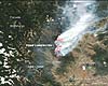 Greenbelt MD (SPX) Aug 08, 2006
In the mountains of northern Washington, the Tripod Complex Fire burned from July into August. This image of the region was captured by the Moderate Resolution Imaging Spectroradiometer (MODIS) on NASA's Aqua satellite on August 6, 2006. Places where MODIS detected actively burning fires are marked in red. |
|
| The content herein, unless otherwise known to be public domain, are Copyright 1995-2006 - SpaceDaily.AFP and UPI Wire Stories are copyright Agence France-Presse and United Press International. ESA PortalReports are copyright European Space Agency. All NASA sourced material is public domain. Additionalcopyrights may apply in whole or part to other bona fide parties. Advertising does not imply endorsement,agreement or approval of any opinions, statements or information provided by SpaceDaily on any Web page published or hosted by SpaceDaily. Privacy Statement |