|
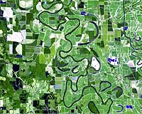
Washington (UPI) Apr 28, 2005 Tiny adjustments are planned over the next 20 months to allow unprecedented accuracy in the national system that enables mapping of everything from air routes to farm fields. The U.S. National Oceanic and Atmospheric Administration Wednesday said it plans to correct small inaccuracies in the National Spatial Reference System, the national coordinate system used in all kinds of mapping and surveying activities around the country. The corrections will begin in June and are scheduled for completion by Feb. 10, 2007 - the 200th birthday of the National Geodetic Survey, a division of NOAA, which defines and manages the NSRS. The changes will be big ones for professionals who use the data and who require the highest standards of accuracy, but won't be perceptible to the average user, such as those using Global Positioning System units that come embedded in cars or boats, Dave Doyle, chief geodetic surveyor with the NGS, told United Press International. "The biggest change we'll see will be around 1 to 5 centimeters," he said. Glen Gibbons, group editorial director and associate publisher of GPS World magazine, based in Eugene, Ore., agreed. For the average user, he told UPI in an e-mail, "I wouldn't expect that we would see much of an effect, because the sum total change over the whole NSRS network probably will be less than a meter, maybe centimeters difference. Changes in the calculations of any given point's position within the NSRS should not affect navigation systems (cars, boats, etc.) which are operating in terms of meter or tens of meter accuracy." The man who worked with the military for six years to develop GPS technology, Brad Parkinson of Stanford University in Palo Alto, Calif., said the readjustment would be veryimportant for calculations related to the figure of the Earth. Parkinson is a professor of aeronautics and astronautics and founder of Stanford's GPS lab. "My guess is that this change will be very small and subtle. I don't guess you're going to see any major shifts in the GPS coordinates of things as they've been calculated in our previous reference frame and our next reference frame," Parkinson said. "But I think that in understanding the Earth itself, it's very important that we do this and that we have a reference frame that reflects what our most accurate understanding of the figure of the Earth really is. A lot of people rely on this for looking at ocean tides and determining what their true heights are, things of that nature, and I just commend (NGS) for pressing ahead." As GPS technology has become more accessible and affordable over the past 20 years, the ways it is used and the number of users have grown exponentially over thepast decade or so, Doyle said. That includes those who use ordinary GPS receivers with accuracies of 2 to 6 meters, and those that require a much higher degree of accuracy, such as surveyors, engineers and geophysicists. "Twenty-five years ago I could have named every surveyor that had GPS equipment outside of our organization. Today it's virtually limitless," he said. Concurrently, the demand for accuracy has increased, he said. "The requirements for the community of users have increased dramatically. People who 15 or 20 years ago would have said ... (an inaccuracy of) 5, 10, 15 centimeters, gee that's good ... but today, 2 or 3 centimeters, that's the most they can tolerate," Doyle said. "We are looking at removing distortions of 1 to 3 centimeters, which is the demand that has been placed on this data by the surveying and mapping public." The readjustment will incorporate hundreds of thousands of GPS observations taken since the last general readjustment in 1986, he said. Doyle noted that while hardly anyone thinks much about the NSRS - which specifies latitude, longitude, height, scale and gravity throughout the nation - it plays a huge part in everyday life, aiding in air, marine and land navigation. "The NSRS is a very significant part of our national infrastructure. Unfortunately, the vast majority of people in this country know nothing about it," he said. "Virtually everything we do is related to mapping - we map everything - we map streets, we map navigation systems, we map diseases, we map anything you can think of." According to the NOAA Web site, the NSRS is the foundation for transportation, communication, mapping, charting and many scientific and engineering applications. Airports and harbors rely on NSRS data for a variety of navigational needs, including identifying obstructions and hazards in the air and under water. NSRS data also is critical in identifying safe flood evacuation routes. The data help state and local highway planners with road construction. During recent hurricanes in Florida, GPS data allowed those monitoring the hurricane and coordinating relief efforts to accurately assess damage and where help was needed to within a few centimeters, Doyle explained. "Having that digital imagery from an airplane flying at 10,000 feet gives you that broad perspective that you need to do effective relief activities," Doyle said. With the increase in world travel in recent years, airlines have become one of the biggest users of GPS and have been one of the strongest voices calling for accuracy upgrades, Doyle said. Airlines are "certainly one of the groups forcing this dynamic change around the world," he said. "What the pilot wants to be assured of is when you flyto a coordinate in space that it's actually at the end of a runway." There are many so-called non-traditional user groups that require highly accurate GPS technology - for instance, cranberry growers who use it in what's known as precision agriculture, Doyle said. With states implementing stricter environmental regulations, cranberry growers who use pesticides and fertilizers need to map their land parcels accurately and give the right information to whoever distributes the chemicals to make sure they are placed in "exactly the right spots," he said. The readjustment also is part of NOAA's efforts to create a Global Earth Observation System of Systems, an international framework connecting technology in space, in the oceans and on land so scientists in different countries can create compatible observation systems, NOAA's Web site said. Such a system would result in improved weather forecasts and navigation, as well as the mapping of diseases, hazardous waste and other global events or concerns, Doyle said. Part of the challenge in trying to create this is that while the United States allows anyone to download the data free of charge, many other countries historically have restricted access to such information. "This is the kind of data in Romania, prior to the fall of (former dictator) Ceausescu, this was the kind of stuff they stood you up against a wall for," he said. "Much of this data has been the kind of thing that historically has been very classified - wherever the important places in your country are strategically are pretty important things and you don't want to release that kind of information. "When we work with other countries, particularly those that have had a history or a tendency in the past to keep their data sort of locked away or secretive or ... difficult to get at, we help them design systems so their data becomes freely available to the public, to the extent it's possible and practical to influence those governments. "It's really been a struggle ... (for governments) to come to grips with the fact that now we have real global needs for this high-accuracy kind of data," Doyle said. "There's a lot of things that have no political boundaries to them. Even if we have our own arbitrary political boundaries there's things in the environment that don't." Community Email This Article Comment On This Article Related Links SpaceDaily Search SpaceDaily Subscribe To SpaceDaily Express GPS Applications, Technology and Suppliers
 San Jose CA (SPX) Jan 04, 2006
Continuing to drive GPS further into the mainstream market, SiRF Technology Holdings has revealed that its flagship SiRFstarIII GPS technology is at the heart of TomTom's RIDER, a high performance portable navigation system specifically designed for use on motorcycles and scooters. TomTom is a leading provider of personal navigation products and services to the US and European consumer markets. |
|
| The content herein, unless otherwise known to be public domain, are Copyright 1995-2006 - SpaceDaily.AFP and UPI Wire Stories are copyright Agence France-Presse and United Press International. ESA PortalReports are copyright European Space Agency. All NASA sourced material is public domain. Additionalcopyrights may apply in whole or part to other bona fide parties. Advertising does not imply endorsement,agreement or approval of any opinions, statements or information provided by SpaceDaily on any Web page published or hosted by SpaceDaily. Privacy Statement |