 |
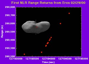
Laurel - March 2, 2000 - On February 29, 2000 NEAR recorded another first: the NEAR Laser Rangefinder (NLR) detected the first laser returns from Eros at a range of 290 km. This is the first time that ranging returns have been detected from an asteroid. NLR was designed to operate at 50 km range, and its successful detection of Eros at 290 km augurs well for the future. The laser rangefinder data will give us a three-dimensional view of the asteroid surface, nicely complementing the information from images. This is because imagers record the distribution of brightness as a function of angles perpendicular to the line-of-sight, whereas the laser rangefinder measures distance to the surface along the line-of-sight. The combination of the two data sets will be powerful, as we hope it will enable us to probe into shadowed regions (because the laser does not depend on solar illumination), and to distinguish between effects of albedo variations and effects of height variations. In an image, a spot may look brighter or darker because of reflectivity differences or because of lighting differences caused by topography (such as shadowing). Laser rangefinder data can be used to separate these effects and to measure topography - e.g., the heights of ridges, the depths of grooves and craters. The image-of-the-day for 2000 February 25 shows the "eastern and western hemispheres" of Eros. The image shows an amazing diversity of geologic features, which will be the subjects of updates in the coming weeks. For now, I will focus on how we define eastern and western hemispheres and how we locate positions on a celestial body. I feel I should apologize for using the word "hemisphere" to refer to an irregularly shaped body like Eros, but I don't have another word that means "the surface within a 180-degree longitude range". To locate any point on the surface, we use what we call "spherical polar coordinates": the longitude and latitude angles, and the distance from the center of Eros. These three numbers specify the position of any point in three dimensions, but we need to specify which way is "north" and which way is "east". To accomplish this, we first locate the rotation axis of Eros using (for example) image data, and we choose the North pole direction as the reference for latitude, the same as is done for Earth. When viewed from above the north pole, the asteroid rotates counterclockwise; when viewed from the south, it rotates clockwise. The latitude angle is measured from the equator of Eros, which is the plane perpendicular to the rotation axis. Having defined the polar axis, the next step is to define the prime meridian, from which longitudes are measured. On Earth, the prime meridian runs through the poles and through Greenwich, UK. On Eros, a particular crater has been selected to mark the prime meridian. If one walks from the prime meridian in the direction of the rotation, one is going east. In the opposite direction, one is going west. Longitudes can be measured going east from the prime meridian, in which case we speak of east longitude, or they can be measured going west from the prime meridian, giving west longitude. Just to keep us on our toes, geophysicists commonly use east longitudes whereas geologists and cartographers commonly use west longitudes. Unfortunately, there is still another complication, which is that the International Astronomical Union defines "north" in reference to the so-called "invariable plane" which is close to the ecliptic plane defined by Earth's mean motion around the Sun, whereas we have just defined it in reference to the rotation of Eros - but fortunately, the two definitions of "north" coincide for Eros, so we can forget about the invariable plane. I guess scientists have a talent for making even the simplest things seem complicated.
Email This Article Comment On This Article Related Links Space
 Calcutta, India (SPX) Dec 28, 2005
The successful launch Thursday of India's heaviest satellite from spaceport of Kourou in French Guyana may have boosted the country's space research efforts to yet another level, but it has also lifted the spirits of at least three Direct-To-Home televisions broadcasters, one of which has been waiting for years to launch its services in India. |
|
|
|
|
|
|
|
|
|
|
|
|
|
| The content herein, unless otherwise known to be public domain, are Copyright 1995-2006 - SpaceDaily.AFP and UPI Wire Stories are copyright Agence France-Presse and United Press International. ESA PortalReports are copyright European Space Agency. All NASA sourced material is public domain. Additionalcopyrights may apply in whole or part to other bona fide parties. Advertising does not imply endorsement,agreement or approval of any opinions, statements or information provided by SpaceDaily on any Web page published or hosted by SpaceDaily. Privacy Statement |
