|
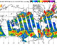
Pasadena - Feb 22, 2002 In a move to improve global weather forecasts and ultimately save lives and property, the United States and Europe have incorporated wind speed and direction data from NASA's Quick Scatterometer spacecraft--also known as Quikscat--into their operational global weather analysis and forecast systems. Armed with data from Quikscat, forecasters can now predict hazardous weather events over the oceans as much as six to 12 hours earlier. Launched June 19, 1999, the Quikscat spacecraft operates in a Sun-synchronous, 800-kilometer (497-mile) near-polar orbit, circling Earth every 100 minutes, taking approximately 400,000 measurements over 93 percent of Earth's surface every day. In recent years, data from the Quikscat scatterometer, developed by NASA's Jet Propulsion Laboratory, Pasadena, Calif., have proven useful in improving forecasts of extreme wind events, such as hurricanes, and in monitoring longer-term climatic effects such as El Nino. Quikscat's SeaWinds scatterometer instrument is a specialized microwave radar that continuously measures both the speed and direction of winds near the ocean surface in all weather conditions. Participants in the Quikscat program include the National Centers for Environmental Prediction, a branch of the National Weather Service, Washington, D.C., and the European Centre for Medium-Range Weather Forecasts, Reading, England. These organizations' decision to assimilate and turn Quikscat data into operational information culminates an intense inter-agency and international cooperative effort among NASA, the National Oceanic and Atmospheric Administration (NOAA) and European countries to demonstrate and validate Quikscat's potential impact on weather forecasting. "Our implementation of Quikscat data has provided another useful data source for improved surface wind forecasts," said Stephen Lord, director of the National Centers for Environmental Prediction's Environmental Modeling Center, which developed the Quikscat data processing in collaboration with NASA and NOAA Satellite Service. "The use of Quikscat data to improve weather forecasts underscores the value of the mission beyond the scientific research community," said Dr. Michael Freilich, Quikscat principal investigator and a professor at Oregon State University, Corvallis. "Realizing the full potential of Quikscat data is possible only because of a series of unique collaborations. NASA researchers and engineers worked together to develop and calibrate the instrument and algorithms. "NOAA personnel, in partnership with NASA, enable rapid delivery of near-real-time spacecraft data to forecast centers. There also are the teams of meteorologists who are developing and refining computer programs that incorporate the data into models and display measurements for forecasters." Helen Wood, director of NOAA's Office of Satellite Data Processing and Distribution, said Quikscat data would positively impact NOAA's weather forecasting and storm warnings. "Quikscat data will help our forecasters more accurately determine the paths and intensities of severe winter storms, tropical storms and hurricanes, which saves lives and property," she said. "The data are also used by climate change researchers and commercial shipping interests." The incorporation of Quikscat data was one of several recent upgrades made to the European Centre for Medium-Range Weather Forecasts' operational system. Cumulatively, the upgrades have resulted in a robust improvement in forecasts of atmospheric conditions over the Southern Hemisphere and in the upper atmosphere. Their ability to forecast tropical cyclone tracks has also been enhanced. JPL manages Quikscat for NASA's Office of Earth Science, Washington, D.C. JPL also built the scatterometer instrument and provides ground science processing systems. NASA's Goddard Space Flight Center, Greenbelt, Md., managed development of the satellite, designed and built by Ball Aerospace & Technologies Corp., Boulder, Colo. Community Email This Article Comment On This Article Related Links Quikscat Tropical Update SpaceDaily Search SpaceDaily Subscribe To SpaceDaily Express Earth Observation News - Suppiliers, Technology and Application
 New York NY (SPX) Jan 11, 2006
The importance of remotely sensed data and technologies to support natural disasters has prompted attention and action in Washington. New initiatives and legislation authorizing appropriations to the remote sensing industry will be discussed at Strategic Research Institute's U.S. Commercial Remote Sensing Industry conference, scheduled for February 9-10, 2006 in Washington D.C. |
|
| The content herein, unless otherwise known to be public domain, are Copyright 1995-2006 - SpaceDaily.AFP and UPI Wire Stories are copyright Agence France-Presse and United Press International. ESA PortalReports are copyright European Space Agency. All NASA sourced material is public domain. Additionalcopyrights may apply in whole or part to other bona fide parties. Advertising does not imply endorsement,agreement or approval of any opinions, statements or information provided by SpaceDaily on any Web page published or hosted by SpaceDaily. Privacy Statement |