 |
Bethesda - Mar 07, 2003 From Canada to Central America, the many grandeurs of North America's diverse topography star in a just-released high-resolution map from NASA's Shuttle Radar Topography Mission (SRTM). But a relatively obscure feature, all but hidden in the flat limestone plateau of Mexico's Yucatan Peninsula, is what emerges as the initial showstopper from the mission's first released continental data set. The existence of the impact crater, Chicxulub, was first proposed in 1980. In the 1990s, satellite data and ground studies allowed it to gain prominence among most scientists as the long sought-after "smoking gun" responsible for the demise of the dinosaurs and more than 70 percent of Earth's living species 65 million years ago. The SRTM has provided the most telling visible evidence to date of a 180-kilometer (112-mile) wide, 900-meter (3,000-foot) deep impact crater, the result of a collision with a giant comet or asteroid on one of Earth's all-time worst days. "This new, complete North American data set greatly expands our topographic knowledge of Canada, southern Alaska and its Aleutian Islands, Mexico and Central America," said Dr. Michael Kobrick, SRTM project scientist at NASA's Jet Propulsion Laboratory (JPL), Pasadena, Calif. "There are spectacular features that pop out in these maps as never before, and more subtle features, like Chicxulub, become apparent for the first time. In fact, much of the surface expression of Chicxulub is so subtle; if you walked across it you probably wouldn't notice it. That's where the view from space becomes invaluable, " Kobrick said. The Chicxulub data show a subtle, yet unmistakable, topographic indication of the impact crater's outer boundary: a semicircular trough 3 to 5 meters (10 to 15 feet) deep and 5 kilometers (3 miles) wide. Scientists believe the impact, centered off Yucatan's coast in the Caribbean, disturbed the subsurface rocks, making them unstable. The rocks were subsequently buried by limestone sediments, which erode easily. The crater rim's instability caused the limestone to fracture along the rim, forming the trough. In addition, the collapse of numerous limestone caverns above the crater rim resulted in an arcing chain of sinkholes, called cenotes, that are visible as small, circular depressions. Exactly how the Chicxulub impact caused Earth's mass extinctions is not known. Some scientists think it threw massive quantities of dust into the atmosphere, blocking the sun and stopping plants from growing. Others believe sulfur released by the impact lead to global sulfuric acid clouds that blocked the sun and also fell as acid rain. Another possibility is global wildfires triggered by atmospheric reentry of red-hot debris. The remainder of the North American data paints a dynamic portrait of a geologically complex continent. Active structural deformations of Earth's crust along and near the Pacific/North American tectonic plate boundary create the diverse topographic relief of the Pacific coast. Across the Great Plains, erosional patterns dominate, with stream channels surrounding and penetrating remnants of older smooth slopes. In Canada and the northern U.S., evidence of glaciers from the last ice age abounds. In February, NASA finished processing the mission's data and delivered it to the National Imagery and Mapping Agency (NIMA). More than eight terabytes of data recorded aboard the Space Shuttle Endeavour were refined into 200 billion research-quality measurements of Earth's landforms. The NIMA will perform additional data finishing and send it to the U.S. Geological Survey's Earth Resources Observation Systems Data Center, Sioux Falls, S.D., for final archiving and distribution. South America will be the next continental dataset. The SRTM, flown Feb. 11 to 22, 2000, made 3-D measurements of the more than 80 percent of Earth's landmass located between 60 degrees north and 56 degrees south of the equator; areas home to nearly 95 percent of the world's population. SRTM is a cooperative project of NASA, NIMA, the Department of Defense, the German and Italian space agencies. Fulfilling part of NASA's mission to understand and protect our home planet, it is managed by JPL for NASA's Earth Science Enterprise, Washington. The California Institute of Technology in Pasadena manages JPL for NASA. Community Email This Article Comment On This Article Related Links New North America Radar Map SRTM at JPL National Imagery & Mapping Agency SpaceDaily Search SpaceDaily Subscribe To SpaceDaily Express Asteroid and Comet Impact Danger To Earth - News and Science
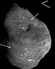 College Park MD (SPX) Sep 07, 2005
Painting by the numbers is a good description of how scientists create pictures of everything from atoms in our bodies to asteroids and comets in our solar system. Researchers involved in NASA's Deep Impact mission have been doing this kind of work since the mission's July 4th collision with comet Tempel 1. |
|
| The content herein, unless otherwise known to be public domain, are Copyright 1995-2006 - SpaceDaily.AFP and UPI Wire Stories are copyright Agence France-Presse and United Press International. ESA PortalReports are copyright European Space Agency. All NASA sourced material is public domain. Additionalcopyrights may apply in whole or part to other bona fide parties. Advertising does not imply endorsement,agreement or approval of any opinions, statements or information provided by SpaceDaily on any Web page published or hosted by SpaceDaily. Privacy Statement |

