|
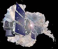
Greenbelt MD (SPX) Dec 15, 2004 The Earth is a dynamic entity, and scientists are trying to understand it. Various things in nature grow and shrink, such as ice sheets, glaciers, forests, rivers, clouds and atmospheric pollutants, serving as the pulse of the planet and affecting many people in many walks of life. Scientists using NASA's Ice, Cloud, and land Elevation Satellite (ICESat) are measuring the height of these dynamic features from space with unprecedented accuracy, providing a new way of understanding our changing planet. ICESat has lasers onboard that help it make the most accurate measurements ever.
Focus on the Freeze Recently ICESat confirmed accelerated movement of glaciers in the Antarctic Peninsula, following the breakup of the floating ice shelf into which the glaciers flowed. ICESat also confirmed that part of the West Antarctic ice sheet has been the increasingly getting thinner. By knowing all of these changes in snow and ice, scientists have a better idea of how melting areas affect the rise of sea level. Picture a polar bear on an icy surfboard. ICESat is also measuring the height of "Sea Ice Freeboards," or ice and snow that are floating above the ocean's surface, to an average between 12 to 16 inches (30 to 40 centimeters). Imagine being able to determine how thick an "icy surfboard" is by only a foot. Watching the changes in the thickness of sea ice is necessary for reliably forecasting the possible disappearance of the Arctic sea ice pack during the summertime months. In winter 2004, ICESat showed thicker sea ice grouped together in its usual place near the Canadian Arctic than it was in 2003. ICESat also showed a larger area of thinner ice in the Beaufort and Chukchi Seas where the summer ice cover has been rapidly decreasing. The location and amount of ice is important to climatologists and also ships that travel those seas.
Capturing the Clouds for Clues on Climate and Weather ICESat has also allowed scientists to see in 3-D the clouds that form in the upper atmosphere near the poles, called "polar stratospheric clouds." These clouds are responsible for the formation of the "ozone holes" over the poles where a break down the protective ozone layer in the stratosphere occurs in the spring. The layer of the atmosphere below the stratosphere is called the troposphere. The troposphere can be divided into two parts, a planetary boundary layer, PBL, extending upward from the ground to a few thousand feet high, and a "free atmosphere" that lies above it. ICESat provided the first global estimation of the top of the PBL. Since the PBL is where heat and moisture from the surface is held, its height is an important new observation for computer models that predict climate and weather. It's also the place where pollution gets trapped down at the surface where we live. Some places we know it as smog on the ground. Pollution affects everyone. Over the whole world the small particles in man made haze are now known to be an important factor causing the climate to change. We now have the first global measurement from ICESat of the height distribution of these tiny particles of pollution.
Lands, Lakes and More "ICESat is making unprecedented measurements of the height of forests from space," said David Harding, of NASA's Goddard Space Flight Center in Greenbelt, Md. Traditional satellite images tell us about how far a forest extends, but not the height of the top, or canopy of a forest. Scientists are interested in knowing that, because it clues them into how much carbon is absorbed in trees. That's important because carbon dioxide is a key greenhouse gas that traps heat in the lower atmosphere and warms the Earth. ICESat's forest top measurements are accurate down to one meter (3.2 feet). In addition to vegetation or forest height, ICESat also provides very precise measurements of land elevations. ICESat's data is being combined with data from the Shuttle Radar Topography Mission (SRTM), a joint mission by NASA, JPL, and the Department of Defense flown in 2000, to create the most accurate global topographic data available for the Earth. In the face of growing worldwide populations, monitoring and managing global water resources are becoming increasingly important. ICESat can measure the changing height of inland water bodies, including rivers, lakes, reservoirs and wetlands. These measurements can even be made of water surfaces even where they are covered by vegetation, such as in flooded forests of the Amazon. ICESat's new data, collected around the globe in 2003 and 2004, has given scientists the ability to see the way many things around the Earth change, from the polar ice sheets and oceans to rainforests. Community Email This Article Comment On This Article Related Links SpaceDaily Search SpaceDaily Subscribe To SpaceDaily Express Earth Observation News - Suppiliers, Technology and Application
 New York NY (SPX) Jan 11, 2006
The importance of remotely sensed data and technologies to support natural disasters has prompted attention and action in Washington. New initiatives and legislation authorizing appropriations to the remote sensing industry will be discussed at Strategic Research Institute's U.S. Commercial Remote Sensing Industry conference, scheduled for February 9-10, 2006 in Washington D.C. |
|
| The content herein, unless otherwise known to be public domain, are Copyright 1995-2006 - SpaceDaily.AFP and UPI Wire Stories are copyright Agence France-Presse and United Press International. ESA PortalReports are copyright European Space Agency. All NASA sourced material is public domain. Additionalcopyrights may apply in whole or part to other bona fide parties. Advertising does not imply endorsement,agreement or approval of any opinions, statements or information provided by SpaceDaily on any Web page published or hosted by SpaceDaily. Privacy Statement |