|
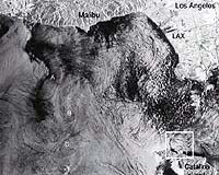
Edwards - Apr 17, 2003 NASA and the Naval Research Laboratory will take a closer look at the swirling water phenomenon known as coastal eddies when they fly a specially-instrumented NASA airborne sciences DC-8 jet off the Southern California coast this month. Coastal eddies can be an important source of transporting nutrients from deep to surface waters, where they stimulate ocean plant growth. They can also transport pollutants from land and recirculate them for days, with both positive and negative consequences for marine life. Yet, while they are common in the global coastal seas, surprisingly little is known about them, due to their small size and transient nature, which have made it very difficult for ships to locate and measure their properties. Scientists from NASA's Jet Propulsion Laboratory, Pasadena, Calif., and the Naval Research Laboratory, Washington, D.C., will use the JPL-designed and built Airborne Synthetic Aperture Radar, or AirSar, instrument to study an area known as the Southern California Bight, between Point Conception and San Diego. During daily flights, AirSar will capture eddy image sequences in rapid succession, enabling researchers to measure motions caused by the currents. A key focus of the research will be spiral-shaped slicks, or glassy water, on the ocean surface that may result from small eddies, which are generally between 4.8 to 9.7 kilometers (3 to 6 miles) in diameter. Theories predict these spirals take several days to evolve. "We can study the currents as they wind-up the ocean slicks into spiral patterns, and we can study the types of currents that either create or do not create eddies," said Dr. George Marmorino, coastal eddies lead scientist for the Naval Research Laboratory. The DC-8, based at NASA's Dryden Flight Research Center, Edwards, Calif., is vital to this project because it can be precisely positioned where needed over consecutive days. Once a clear ocean eddy is detected from the DC-8, its position will be relayed to oceanographers on the Sea World UCLA, a research vessel that can measure the deeper currents and density structure associated with the eddy. Additional satellite imagery will also help to identify eddy locations. Scientists hope the unique combination of AirSar flights, ship measurements and satellite ocean sensors will enable them to better understand the characteristics of these small but important coastal features. Collaborators in the study include the University of California, Los Angeles, departments of Civil and Environmental Engineering and Atmospheric Sciences; and the Scripps Institution of Oceanography, University of California, San Diego. Community Email This Article Comment On This Article Related Links Ocean Coastal Eddies AirSar NASA's DC-8 SpaceDaily Search SpaceDaily Subscribe To SpaceDaily Express Earth Observation News - Suppiliers, Technology and Application
 New York NY (SPX) Jan 11, 2006
The importance of remotely sensed data and technologies to support natural disasters has prompted attention and action in Washington. New initiatives and legislation authorizing appropriations to the remote sensing industry will be discussed at Strategic Research Institute's U.S. Commercial Remote Sensing Industry conference, scheduled for February 9-10, 2006 in Washington D.C. |
|
| The content herein, unless otherwise known to be public domain, are Copyright 1995-2006 - SpaceDaily.AFP and UPI Wire Stories are copyright Agence France-Presse and United Press International. ESA PortalReports are copyright European Space Agency. All NASA sourced material is public domain. Additionalcopyrights may apply in whole or part to other bona fide parties. Advertising does not imply endorsement,agreement or approval of any opinions, statements or information provided by SpaceDaily on any Web page published or hosted by SpaceDaily. Privacy Statement |