|
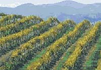
San Bernabe - Aug 20, 2003 A small, unmanned aerial vehicle (UAV) has made test flights over the world's largest vineyard in California Aug. 19 to prepare for nighttime frost studies early next year. The UAV - a remotely piloted aircraft - is bigger than a model airplane but smaller than a light plane. NASA, university and industry teams are testing the UAV, its imaging and other data-collecting systems, as well as preparing the test team. The test flights took place over San Bernabe Vineyard, which is located just west of King City and midway between two California cities, Salinas and Paso Robles-about 50 miles from the two. "We are developing wireless operation of a new sensing device that will remotely gauge temperature and other conditions while flying over the grapes," said Stanley Herwitz, director of the Clark University UAV Applications Center at NASA Research Park, next to NASA Ames Research Center, Moffett Field, Calif., and professor of Earth science from Clark University, Worcester, Mass. Remote sensing is the use of sensors by satellites and aircraft to take images of parts of the Earth's surface in many wavelengths, some beyond the reach of the human eye. This technology enables scientists to quickly deduce surface conditions over a wide area, the equal of hundreds of hours of observation on the ground. "Even though management has significant historical experience in temperature monitoring, it is a very imprecise process," said San Bernabe's chief operating officer, Claude Hoover. "Given the high cost and potential limited resource availability for frost protection, improving the accuracy and timeliness of information can have significant economic benefit," Hoover explained. Frost damage can decrease annual grape yields by more than 50 percent, according to Hoover. Such a decrease would amount to a loss in revenue of more than $12,000,000 for this vineyard alone. "The flight window over the vineyard was from midnight to 6 a.m. PST," Herwitz said. "Fixed flight lines over the vineyard were flown repeatedly. The imagery was downlinked to our ground station that was established in the vineyard data management office located less than 100 meters from the vineyard's private airstrip," he added. The UAV airplane transmits thermal images and Global Positioning System (GPS) information to be overlaid on irrigation maps, showing how the small UAV can help grape growers monitor frost in large areas of vines. "The per image delivery time to the vineyard manager was within 15 minutes of acquisition," Herwitz said. This technology also may be useful for monitoring orchards and other frost-sensitive crops. The UAV's infrared camera systems are calibrated to read out temperature directly. Thermal images from the UAV showing temperature trends and rates of change will help vineyard managers to make key decisions about the timing of irrigation treatments. "In contrast to UAV sensors, handheld or vehicle-mounted frost-monitoring systems are labor intensive," Herwitz said. "It simply is not possible to have a work force distributed over a 20-square-mile stretch of vineyard, such as San Bernabe's, throughout the night. "Work fatigue at night is a compounding issue. In addition, sampling on the ground is restricted to road networks, and, as a result, fails to sample high-risk zones in the field interiors," he explained. In addition, stationary ground-based sensors that make up frost alarm networks are limited in number and require labor-intensive maintenance, according to Herwitz. "These ground-based sensors also are vulnerable to disturbance and degradation by farm operations, wild animals such as rodents and exposure to the weather." "Fee-based Web site weather data are not specific to the geographic units for where frost control measures might be needed," he added. Smaller UAVs, like the one to be flown during the grape test missions, cost less than larger UAVs. In addition, recent advances in navigation systems make small UAVs easier to fly. A wireless computer local area network (LAN) operating in the unlicensed 900 Mhz radio band provided instrument control and data downlink of images and other information at up to a 75-kilometer (almost 50-mile) range. A portable radar system was another important component used during the mission to monitor the activity of other aircraft flying in the vicinity of the tests in the national airspace. Researchers will share the results of their March-to-May 2004 UAV frost-detection mission at the annual meeting of the California Vintners' Association. "The long-term commercial significance of our new technology is its potential value to the wine vineyard community throughout the north and central coast regions of California, which are subject to extremely variable seasonal frost conditions," Herwitz said. The technology also may be good for use in other grape and orchard regions, such as Washington and Oregon, Herwitz concluded. Community Email This Article Comment On This Article Related Links SpaceDaily Search SpaceDaily Subscribe To SpaceDaily Express Farming Today - Suppliers and Technology
 College Station TX (SPX) Dec 01, 2005
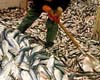
Fish pulled from the world's lakes and rivers seem to provide a never-ending source of food, jobs and income for people in developing nations. |
|
| The content herein, unless otherwise known to be public domain, are Copyright 1995-2006 - SpaceDaily.AFP and UPI Wire Stories are copyright Agence France-Presse and United Press International. ESA PortalReports are copyright European Space Agency. All NASA sourced material is public domain. Additionalcopyrights may apply in whole or part to other bona fide parties. Advertising does not imply endorsement,agreement or approval of any opinions, statements or information provided by SpaceDaily on any Web page published or hosted by SpaceDaily. Privacy Statement |