|
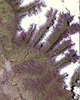
Pasadena - Apr 14, 2003 An Earth-monitoring instrument aboard NASA's Terra satellite is keeping a close eye on a potential glacial disaster-in-the-making in Peru's spectacular, snow-capped Cordillera Blanca (White Mountains), the highest range of the Peruvian Andes. Data from NASA's Advanced Spaceborne Thermal Emission and Reflection Radiometer (ASTER) is assisting Peruvian government officials and geologists in monitoring a glacier that feeds Lake Palcacocha, located high above the city of Huaraz, 270 kilometers (168 miles) north of Lima. An ominous crack has developed in the glacier. Should the large glacier chunk break off and fall into the lake, the ensuing flood could hurtle down the Cojup Valley into the Rio Santa Valley below, reaching Huaraz and its population of 60,000 in less than 15 minutes. "Remote sensing instruments like ASTER can serve a vital role in mountain hazard management and disaster mapping by providing rapid access to data, even in regions not easily accessible by humans," explained Dr. Michael Abrams, associate ASTER team leader at NASA's Jet Propulsion Laboratory, Pasadena, Calif. "ASTER's unique vantage point from space gives scientists another tool with which to see early signs of potential glacial flood-burst events and to monitor changes in glacial behavior over time. "In Huaraz, Peruvian authorities and scientists will incorporate ASTER data along with data from ground-based monitoring techniques to better assess current conditions and take steps necessary to reduce risks to human lives and property," Abrams said. Huaraz can be seen in the images' left-center, with Lake Palcacocha in the images' upper right corners at the head of a valley, below the snow and glacier cap. The left image was acquired on November 5, 2001; the right on April 8, 2003. Glacial flood-bursts, known by Peruvians as "aluviones," occur periodically when water is released abruptly from a previously ice-damned lake alongside, within or above a glacier. The release can be caused by various triggering events. These flood-bursts typically arrive with little or no warning, carrying liquid mud, large rock boulders and blocks of ice. The Rio Santa Valley is no stranger to such disasters. Since 1702, floods caused by glaciological conditions have repeatedly caused death and destruction in the region. One particularly devastating event in 1941 destroyed approximately one-third of Huaraz, killing an estimated 5,000 to 7,000 people. Since then, the Peruvian government has emphasized control of the water level in Lake Palcacocha and other lakes in the region that pose similar threats. The efforts appear to have worked; since 1972, no destructive floods resulting from the breakout of glacial lakes have occurred. Nevertheless, officials are still monitoring the current situation closely. ASTER's broad spectral coverage and high spectral resolution is ideally suited for monitoring dynamic conditions and changes in Earth's landscape over time, including glacial advances and retreats. Its 14 spectral bands measure from the visible to the thermal infrared wavelength region, and it can "see" at a resolution of 15 to 90 meters (about 50 to 300 feet). ASTER provides scientists in numerous disciplines critical information used for surface mapping and monitoring of dynamic conditions and changes over time.
It can also image the same area as frequently as every other day in response to urgent priorities. ASTER is one of five Earth-observing instruments launched December 18, 1999, on NASA's Terra satellite. Japan's Ministry of Economy, Trade and Industry built the instrument. A joint U.S./Japan science team is responsible for validation and calibration of the instrument and the data products. The Terra satellite is part of NASA's Earth Science Enterprise. Community Email This Article Comment On This Article Related Links More Comparison Images TERRA at NASA SpaceDaily Search SpaceDaily Subscribe To SpaceDaily Express Earth Observation News - Suppiliers, Technology and Application
 New York NY (SPX) Jan 11, 2006
The importance of remotely sensed data and technologies to support natural disasters has prompted attention and action in Washington. New initiatives and legislation authorizing appropriations to the remote sensing industry will be discussed at Strategic Research Institute's U.S. Commercial Remote Sensing Industry conference, scheduled for February 9-10, 2006 in Washington D.C. |
|
| The content herein, unless otherwise known to be public domain, are Copyright 1995-2006 - SpaceDaily.AFP and UPI Wire Stories are copyright Agence France-Presse and United Press International. ESA PortalReports are copyright European Space Agency. All NASA sourced material is public domain. Additionalcopyrights may apply in whole or part to other bona fide parties. Advertising does not imply endorsement,agreement or approval of any opinions, statements or information provided by SpaceDaily on any Web page published or hosted by SpaceDaily. Privacy Statement |