|
Greenbelt - March 20, 2000 - NASA is about to launch the first spacecraft dedicated to imaging the Earth's magnetosphere -- an invisible magnetic field surrounding the planet that is strongly influenced by the solar wind. A Delta II 7326 rocket is scheduled to launch the Imager for Magnetopause-to-Aurora Global Exploration, or IMAGE, satellite into orbit March 25 from the Western Range at Vandenberg Air Force Base, CA. The eight-minute launch window for IMAGE opens at 3:35 p.m. EST (12:35 p.m. PST). IMAGE is the first of its kind, designed to actually "see" most of the major charged-particle systems in the space surrounding Earth. Previous spacecraft explored the magnetosphere by detecting particles and fields they encountered as they passed through them. This technique limited their "vision" to small portions of this vast and dynamic field, which extends about 40,000 miles on Earth's day side and about 110,000 miles on Earth's night side. It would be similar to attempt understanding the nature of the world's oceans from a single buoy. Just as taking a photograph of the night sky allows astronomers to count and study millions of stars at once, images returned by the IMAGE spacecraft will provide simultaneous measurements of the densities, energies and masses of charged particles throughout the inner magnetosphere using three-dimensional imaging techniques. "IMAGE brings to space weather studies the kind of capability that geosynchronous weather satellites have brought to surface meteorology," said Dr. Thomas Moore, IMAGE Project Scientist at NASA's Goddard Space Flight Center, Greenbelt, MD. "We may soon be treated to evening news images of plasma clouds engulfing those weather satellites." During its two-year mission, the half-ton IMAGE spacecraft will image remote particle populations in the magnetosphere. These "photographs" will then be linked together to make movies in real time. Their rapid two-minute cadence will allow detailed study of the interaction of the solar wind with the magnetosphere and the magnetosphere's response during a magnetic storm, which typically lasts a few days. "In addition to stored data, IMAGE will implement a real-time down link that the National Oceanic and Atmospheric Administration intends to use for space weather forecasting," said Principal Investigator Dr. James Burch of the Southwest Research Institute (SwRI), San Antonio, TX. To fulfill its science goals, IMAGE will employ six state-of- the-art instruments along with a data processor. The instruments and their developers are:
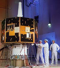
Lockheed Martin Missiles and Space of Sunnyvale, Calif. built the IMAGE spacecraft -- which measures 7.38 feet in diameter and 4.99 feet high -- under contract with SwRI. On orbit, the RPI antennas aboard IMAGE will extend 33 feet parallel to the spin axis and 820 feet in four directions perpendicular to the spin axis, making IMAGE the longest spacecraft currently on orbit.
Email This Article Comment On This Article Related Links Space
 Calcutta, India (SPX) Dec 28, 2005
The successful launch Thursday of India's heaviest satellite from spaceport of Kourou in French Guyana may have boosted the country's space research efforts to yet another level, but it has also lifted the spirits of at least three Direct-To-Home televisions broadcasters, one of which has been waiting for years to launch its services in India. |
|
|
|
|
|
|
|
|
|
|
|
|
|
| The content herein, unless otherwise known to be public domain, are Copyright 1995-2006 - SpaceDaily.AFP and UPI Wire Stories are copyright Agence France-Presse and United Press International. ESA PortalReports are copyright European Space Agency. All NASA sourced material is public domain. Additionalcopyrights may apply in whole or part to other bona fide parties. Advertising does not imply endorsement,agreement or approval of any opinions, statements or information provided by SpaceDaily on any Web page published or hosted by SpaceDaily. Privacy Statement |