|
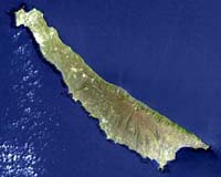
Pasadena CA - Apr 08, 2004 History can be hard to find. A forgotten letter molders in an attic. An ancient temple hides beneath jungle greenery. Even knowing that something is there doesn't necessarily make it easier to find - the classic needle in the haystack. But locating many archaeological sites isn't just difficult; it is required by law. Federal legislation mandates that all archaeological sites on federal lands be located and evaluated by federal managers, particularly if the sites could be damaged by construction or military maneuvers. Legislation also specifically protects Native American burial sites on federal lands. However, less than 10 percent of the more than 700-million acres under federal control have been surveyed, according to a recent National Park Service report. In a conventional survey, archaeologists usually cover an area on foot. Sometimes they have to dig holes to see beneath the surface. It's a slow and expensive procedure. Last year, the defense department's Strategic Environmental Research and Development Program turned to researchers Dr. Ronald Blom, a JPL geologist, and Dr. Douglas Comer, an archaeologist, to see if a JPL instrument with an advanced type of radar could help speed up the process and make it more economical. To test the idea, Blom, Comer and their colleagues set out for San Clemente Island. Controlled by the Navy, the narrow, 16-kilometer-long (25-mile-long) island is about 50 kilometers (31 miles) offshore northwest of San Diego. There are no ancient cities, temples or monuments. However, evidence remains of the Native Americans who camped and fished there for hundreds and thousands of years before the Spanish arrived in the 18th century. "The archaeological sites on San Clemente are usually 10 to 20 meters (33 to 66 feet) wide and marked by rich, organic soil produced by campfires and food remains, scatterings of rock brought there to be used as tools or in windbreaks, and concentrations of shell discarded after shellfish were eaten," says Comer. "In size and character, they are similar to the great majority of archaeological sites in North America." Often the most visible sign of an archaeological site is a change in vegetation, caused by the rich soils. For example, a group of prickly pear cactus in a field of grass may signal that humans changed the environment in that particular location. Small mounds and depressions also show where people lived and worked. Researchers began the old-fashioned way--by closely analyzing some of these known sites on foot. Then they collected radar data over the island with a unique instrument called Airsar, short for airborne synthetic aperture radar. Airsar isn't new to archaeology. In the 1990s, it revealed a previously unknown section of the ancient city of Angkor in Cambodia. This month it is surveying selected archaeological sites in Central America. "Radar is particularly good at describing the physical environment and sensing changes, especially man-made changes," says Blom. The idea in the San Clemente project was to collect Airsar data over a large area, process the data to bring out indications of past human presence, and then combine the results with other information, such as detailed topographical measurements, to target the most likely spots to search for archaeological sites. Radar works by sending out pulses of radio waves and collecting the waves that are reflected back. Airsar is unique because it can send out radio waves of three different lengths and can polarize them both vertically and horizontally. This flexibility allows researchers to modify the radar signals to pick out certain features that signal past human presence. "On San Clemente shorter radar wavelengths seem to be most useful," Blom explains. "There are no big things there, and the short waves work better for small features. Different polarizations help us characterize the shape of objects and tell the difference between vegetation types, for example." The next step was to process the data to reveal a signature of past human activity. They used their knowledge of the sites they had surveyed in person to help. So far, the results are promising. "Yes, we can find archaeological sites," says Blom. "They show up as bright radar spots. Now we need to refine the system and find ways to screen out false positives." The researchers are incorporating the radar results into a geographic information system, where they can be combined with detailed topographical measurements and information on soils, proximity of fresh water, drainage and vegetation. "We're looking for patterns that link the archaeological sites with the island's geography," says Blom. "We know, for example, that most sites will be within 200 meters (about 220 yards) or so of a source of fresh water. So far, radar has not only shown us where many sites are, it has also told us so much about the environment that we know where the sites should be." The final result, they hope, will be a model that can predict which bright spot on the radar image will indeed be a potential archaeological site-in other words, use radar to look at the haystack and predict where the needle will be. "Of course, our ultimate goal," says Blom, "is to identify and protect our cultural heritage so that we can both learn from those who came before and honor them." Community Email This Article Comment On This Article Related Links SpaceDaily Search SpaceDaily Subscribe To SpaceDaily Express Military Space News at SpaceWar.com
 Colorado Springs CO (SPX) Jan 6, 2006
Air Force Reserve Command's 310th Space Group will travel deeper into the space program when it activates a new unit Jan. 7. Headquarters Reserve National Security Space Institute will be a Reserve associate unit to the National Security Space Institute in Colorado Springs, Colo. The institute is the Department of Defense's focal point for providing education about space power in joint warfighting. |
|
| The content herein, unless otherwise known to be public domain, are Copyright 1995-2006 - SpaceDaily.AFP and UPI Wire Stories are copyright Agence France-Presse and United Press International. ESA PortalReports are copyright European Space Agency. All NASA sourced material is public domain. Additionalcopyrights may apply in whole or part to other bona fide parties. Advertising does not imply endorsement,agreement or approval of any opinions, statements or information provided by SpaceDaily on any Web page published or hosted by SpaceDaily. Privacy Statement |