|
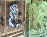
Reston, VA (SPX) Feb 06, 2006 When Hurricane Katrina made landfall in August 2005, it changed the look of some of the coastlines of three U.S. states. Now, using Google Earth�s software on the Internet, people can see the before and after affects, thanks to detailed images from NASA and the U.S. Geological Survey (USGS). The images on Google Earth show changes that Hurricane Katrina made to the Gulf coast from Panama City, Fla. to New Orleans, La. Hurricane Katrina made landfall in south Plaquemines Parish, La., near the towns of Empire, Buras and Boothville, on Aug. 29, 2005, at approximately 7:10 a.m. CDT. It caused widespread destruction in Louisiana, Mississippi, and Alabama and turned out to be the most expensive hurricane in the history of the United States, causing an estimated 80 billion dollars in damages, according to the National Oceanic and Atmospheric Administration. Katrina also turned out to be the deadliest U.S. hurricane since 1928, claiming at least 1,300 lives. The coastlines of those states were forever changed. NASA, using an Atlantic Global Research contract aircraft and the agency�s own advanced technology, made it possible to see how much and what type of damage that Katrina caused when it came ashore. The changes to the coasts were cataloged in detail using NASA's laser mapping system called EAARL (Experimental Advanced Airborne Research Lidar) onboard an airplane. EAARL uses a laser to "see" and measure distance to a surface. EAARL can be used to get closer looks at things like coral reefs, sandy beaches, coastal vegetation, and trees. During the month of September, 2005, 250,000 pictures were taken over 5 days of flying over the coastlines. The EAARL Principal Investigator, Charles W. Wright, of NASA�s Wallops Island Flight Facility, Wallops, Va., placed the imagery online at Google Earth. "This is the first time that I can remember such an easy-to-use tool putting so much data at the fingertips of so many people with so little effort," Wright said. Wright said that the people involved with the project were busy working to bring the lidar data of the New Orleans levees online for FEMA, and had not anticipated that they would be bringing the photography online. The U.S. Geological Survey�s Coastal and Marine Geology Program investigates the how much coastlines change due to hurricanes and other powerful storms. A big benefit to using this is that it will help people make decisions on where to rebuild. Community Email This Article Comment On This Article Related Links EAARL U.S. Geological Survey More pixs of before and after Katrina Bringing Order To A World Of Disasters When the Earth Quakes A world of storm and tempest
 Tallahassee FL (SPX) January 31, 2006
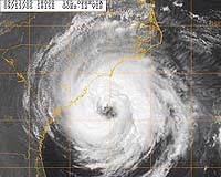
Hurricanes can completely re-structure themselves inside, and that presents forecasters with great uncertainty when predicting their effects on the general population. |
|
| The content herein, unless otherwise known to be public domain, are Copyright 1995-2006 - SpaceDaily.AFP and UPI Wire Stories are copyright Agence France-Presse and United Press International. ESA PortalReports are copyright European Space Agency. All NASA sourced material is public domain. Additionalcopyrights may apply in whole or part to other bona fide parties. Advertising does not imply endorsement,agreement or approval of any opinions, statements or information provided by SpaceDaily on any Web page published or hosted by SpaceDaily. Privacy Statement |