|
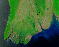
Greenbelt MD (SPX) May 07, 2008 The first cyclone of the 2008 season in the northern Indian Ocean was a devastating one for Myanmar (Burma). According to reports, Cyclone Nargis made landfall with sustained winds of 130 mph and gusts of 150-160 mph, which is the equivalent of a strong Category 3 or minimal Category 4 hurricane. News reports stated that over 100,000 people may have been killed, with tens of thousands more missing as of May 7. Flood water can be difficult to see in photo-like satellite images, particularly when the water is muddy. This pair of images from the Moderate Resolution Imaging Spectroradiometer (MODIS) on NASA's Terra satellite use a combination of visible and infrared light to make floodwaters obvious. Water is blue or nearly black, vegetation is bright green, bare ground is tan, and clouds are white or light blue. On April 15, rivers and lakes are sharply defined against a backdrop of vegetation and fallow agricultural land. The Irrawaddy River flows south through the left-hand side of the image, splitting into numerous distributaries known as the Mouths of the Irrawaddy. The wetlands near the shore are a deep blue green. Cyclone Nargis came ashore across the Mouths of the Irrawaddy and followed the coastline northeast. The entire coastal plain is flooded in the May 5 image. The fallow agricultural areas appear to have been especially hard hit. For example, Yangon (population over 4 million) is almost completely surrounded by floods. Several large cities (population 100,000"500,000) are in the affected area. Muddy runoff colors the Gulf of Martaban turquoise. The high-resolution image provided above is at MODIS' maximum spatial resolution (level of detail) of 250 meters per pixel. The MODIS Rapid Response Team provides twice-daily images of the region in additional resolutions and formats, including photo-like natural color. Community Email This Article Comment On This Article Related Links More images at Goddard. Tropical Cyclone Nargis at NASA's Hurricane Page Earth Observation News - Suppiliers, Technology and Application
 Delhi, India (SPX) May 07, 2008
High quality imageries acquired from Cartosat-2A and Indian Mini Satellite-1 (IMS-1) were presented to the Prime Minister Dr Manmohan Singh in Delhi by Dr G Madhavan Nair, Chairman, ISRO along with a team of senior scientists. It may be recalled that Cartosat-2A and IMS-1 were successfully launched by PSLV-C9 from Satish Dhawan Space Centre SHAR, Sriharikota on April 28, 2008. |
|
| The content herein, unless otherwise known to be public domain, are Copyright 1995-2007 - SpaceDaily.AFP and UPI Wire Stories are copyright Agence France-Presse and United Press International. ESA Portal Reports are copyright European Space Agency. All NASA sourced material is public domain. Additional copyrights may apply in whole or part to other bona fide parties. Advertising does not imply endorsement,agreement or approval of any opinions, statements or information provided by SpaceDaily on any Web page published or hosted by SpaceDaily. Privacy Statement |