|
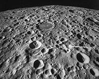
Moffett Field CA (SPX) Oct 27, 2005 Internet users can now take virtual 3-D trips to nearly anyplace on the moon, thanks to a NASA program first designed to show aerial views of the Earth. The newly expanded NASA 'World Wind' computer program can 'transport' Web users to almost anyplace on the moon, when they zoom in from a global view to closer pictures of our natural satellite taken by the Clementine spacecraft in the 1990s. Computer programmers at NASA Ames Research Center in California's Silicon Valley originally designed the World Wind program to deliver satellite images and data of Earth to the Internet. Users can see detailed 3-D pictures of the Earth's land surface, including its elevation and climate. "We have just digested the best of the Clementine images, so we can now deliver the moon at 66 feet (20 meters) of resolution," said Patrick Hogan, manager of the World Wind Project Office at NASA Ames. "This is a first. No one has ever explored our moon in the 3-D interactive environment that World Wind creates," noted Hogan. Launched in early 1994, Clementine took 1.8 million pictures of the lunar surface during a two-month orbit of the moon. The Ballistic Missile Defense Organization and NASA jointly sponsored the Deep Space Program Science Experiment that included the Clementine spacecraft. Its principal objective was to 'space-qualify' lightweight imaging sensors and component technologies for the next generation of Department of Defense spacecraft. "Imagine riding a magic carpet through the world and being able to zoom down to any point, or appear magically at any location. That's what World Wind is like," said Mark Leon, chief of the Education Division at NASA Ames. "Not only has Hogan's team produced new technology with World Wind, but they have done so as open source computer code, so it is free for all who would download it," Leon added. "NASA World Wind allows users to explore their (computer) environment at will," Hogan said. "This leads to much greater engagement with, and by, the users and personalizes it for their own discovery." In contrast, movies are not as engaging, or immersive, in that the user does not control them, Hogan observed. The personal computer (PC) -compatible World Wind program is available free of charge via Internet 'download.' Computer users from more than 100 nations have acquired the free World Wind program, though most users are from the United States. To download World Wind, visit here. NASA World Wind is delivering terabytes of global NASA satellite data that are a result of years of daily observations of precipitation, temperature, barometric pressure and much more. Recently, hurricane Katrina data have been added to World Wind's collection of images. There are an estimated 10,000 daily users of World Wind. In addition to improving World Wind by adding images of the moon, NASA programmers recently have increased the resolution of images of Earth from 3,281-foot (one-kilometer) resolution to 1,640-foot (500-meter) resolution in an upgrade called 'Blue Marble, Next Generation Earth.' Also, some World Wind data sets include images of the entire Earth at 49-foot (15-meter) resolution. The United States data in World Wind is at 3.3-foot (one-meter) resolution with some urban areas at one-foot (0.33-meter) resolution. World Wind has been enabling hundreds of thousands of Internet users to zoom from satellite altitude into any place on Earth to see across the Andes, into the Grand Canyon, over the Alps or along the African Sahara. World Wind accesses public domain United States Geological Survey aerial photography and topographic maps as well as Shuttle Radar Topography Mission and Landsat satellite data. Community Email This Article Comment On This Article Related Links SpaceDaily Search SpaceDaily Subscribe To SpaceDaily Express Mars News and Information at MarsDaily.com Lunar Dreams and more
 Paris, France (ESA) Dec 28, 2005
ESA's SMART-1 spacecraft has been surveying the Moon's surface in visible and near-infrared light using a new technique, never before tried in lunar orbit. |
|
| The content herein, unless otherwise known to be public domain, are Copyright 1995-2006 - SpaceDaily.AFP and UPI Wire Stories are copyright Agence France-Presse and United Press International. ESA PortalReports are copyright European Space Agency. All NASA sourced material is public domain. Additionalcopyrights may apply in whole or part to other bona fide parties. Advertising does not imply endorsement,agreement or approval of any opinions, statements or information provided by SpaceDaily on any Web page published or hosted by SpaceDaily. Privacy Statement |