|
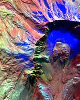
Moffett Field CA (SPX) Oct 05, 2004 NASA scientists took infrared (IR) digital images of Mount Saint Helens last week. The images revealed signs of heat below the surface one day before the volcano erupted last Friday in southern Washington. The images may provide valuable clues as to how the volcano erupted. Scientists flew an IR imaging system aboard a small Cessna Caravan aircraft over the mountain to acquire the data. "Based on the IR signal, the team predicted an imminent eruption," said Steve Hipskind, acting chief of the Earth Science Division at NASA Ames Research Center, located in California's Silicon Valley. "We were seeing some thermal artifacts in the floor of the Mount Saint Helens crater in southern Washington," said Bruce Coffland, a member of the Airborne Sensor Facility at NASA Ames. "We flew Thursday and used the 50-channel MODIS/ASTER Airborne Simulator (MASTER) digital imaging system. We are working to create images from the IR data that depict the thermal signatures on the dome," Coffland added. MASTER is an airborne simulator instrument similar to the Advanced Spaceborne Thermal Emission and Reflection Radiometer (ASTER) high-resolution infrared imager carried on NASA's Terra Earth observation satellite. Scientists plan to fly the MASTER instrument again over the volcano early this week. The NASA Ames airborne sensor team was in the area taking data for a United States Geological Survey (USGS) study examining some of the effects of the 1980 Mount Saint Helens eruption. "This had been planned for some time, and we were there totally by coincidence," Coffland said. The science objectives for the USGS study were to outline the boundaries of the lava flows associated with Mount Saint Helens' previous eruptions in 1980. "We flew four flight lines over the mountain," Coffland said. "It's a continuous scan image, eight miles long (13 kilometers) and about 2.3 miles (3.7 kilometers) wide." There were four adjoining flight lines flown for Joel Robinson, an investigator at USGS, Menlo Park, Calif. After the plane landed, technicians downloaded data from a computer hard drive, and began to process the data to produce an image format for use by scientists. NASA will post the pre and post eruption infrared images on the Web. Sky Research, based in Ashland, Ore., provided the Cessna Caravan, a propeller driven, single-engine airplane that carried the IR imager. Community Email This Article Comment On This Article Related Links SpaceDaily Search SpaceDaily Subscribe To SpaceDaily Express Tectonic Science and News
 Sydney (AFP) Dec 12, 2005
Thousands of tonnes of ash are continuing to spew from a volcano in Vanuatu, but officials said Monday the activity on the South Pacific nation was not likely to result in a major deadly eruption. |
|
| The content herein, unless otherwise known to be public domain, are Copyright 1995-2006 - SpaceDaily.AFP and UPI Wire Stories are copyright Agence France-Presse and United Press International. ESA PortalReports are copyright European Space Agency. All NASA sourced material is public domain. Additionalcopyrights may apply in whole or part to other bona fide parties. Advertising does not imply endorsement,agreement or approval of any opinions, statements or information provided by SpaceDaily on any Web page published or hosted by SpaceDaily. Privacy Statement |