|
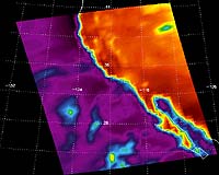
Washington - Apr 30, 2003 Your weatherperson's job just got a little easier, thanks to new data available from advanced weather instruments aboard NASA's Aqua satellite. The new data are the most accurate, highest-resolution measurements ever taken from space of the infrared brightness (radiance) of Earth's atmosphere. This information can be used to make more accurate predictions of weather and climate. The data come from two microwave sounding instruments that are part of the Atmospheric Infrared Sounder (AIRS) experiment: the Atmospheric Infrared Sounder and the Advanced Microwave Sounding Unit. With its visible, infrared and microwave detectors, the AIRS experiment provides a three-dimensional look at Earth's weather. Working in tandem, its instruments can make simultaneous observations from space all the way to Earth's surface, even in the presence of heavy clouds. With more than 2,400 channels sensing different regions of the atmosphere, the system creates a global, three-dimensional map of atmospheric temperature and humidity. AIRS provides information about clouds, greenhouse gases and many other atmospheric phenomena. "The AIRS experiment is demonstrating high sensitivity and accuracy," said Dr. Moustafa Chahine, science team leader at NASA's Jet Propulsion Laboratory (JPL), Pasadena, Calif., which manages the experiment. "Meteorologists around the world have been eagerly awaiting the availability of this processed AIRS data, and are already reporting measurable increases in the accuracy of their short-term weather predictions. NASA and the world's weather prediction agencies can also use AIRS experiment data to better track severe weather events, like hurricanes," he said. Scientists from various organizations echoed Chahine's views. Dr. Tony McNally, of the European Center for Mid-range Weather Forecasts in Reading, England, reported the use of AIRS data resulted in "a small but consistent positive impact on forecast quality in all areas." While Dr. Hank Revercomb, director of the Space Science and Engineering Center at the University of Wisconsin, Madison, called the experiment, "a virtual gold mine of information." And Dr. Louis Ucellini, director of the National Oceanic and Atmospheric Administration (NOAA) National Centers for Environmental Prediction (NCEP), said adopting data from the AIRS experiment is "our number one priority." Chahine said more advanced data products are expected to become available later this year. The data will include atmospheric temperature and humidity profiles, and additional environmental measurements on various types of clouds, particularly the thin veil of cirrus clouds that cover Earth. He also expects new data about concentrations of greenhouse gases, such as carbon dioxide, methane, carbon monoxide and volcanic sulfur dioxide. NOAA is continuing to evaluate the new data, learning how to integrate it and gaining confidence in its accuracy. When that process is completed this summer, NOAA will begin integrating AIRS data into existing weather-prediction models used by NCEP. Six of the world's leading weather- prediction centers will do the same. The data will also be distributed to the World Meteorological Organization in Switzerland, where it will be available to 105 countries. Aqua's planned six-year mission will collect data, using the six onboard instruments, on global temperature variations, the cycling of water, global precipitation, evaporation, changes in ocean circulation, and how clouds and surface- water processes affect climate. The information will help scientists better understand how global ecosystems change, and how they respond to and affect global environmental change. Community Email This Article Comment On This Article Related Links AIRS SpaceDaily Search SpaceDaily Subscribe To SpaceDaily Express Dirt, rocks and all the stuff we stand on firmly
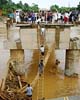 Real, Philippines (AFP) Nov 30, 2004
Rescuers were desperately searching for survivors Tuesday after floods and landslides unleashed by a tropical storm in the Philippines killed more than 300 people and left at least 150 others missing, many buried alive under tonnes of debris. |
|
| The content herein, unless otherwise known to be public domain, are Copyright 1995-2006 - SpaceDaily.AFP and UPI Wire Stories are copyright Agence France-Presse and United Press International. ESA PortalReports are copyright European Space Agency. All NASA sourced material is public domain. Additionalcopyrights may apply in whole or part to other bona fide parties. Advertising does not imply endorsement,agreement or approval of any opinions, statements or information provided by SpaceDaily on any Web page published or hosted by SpaceDaily. Privacy Statement |