 |
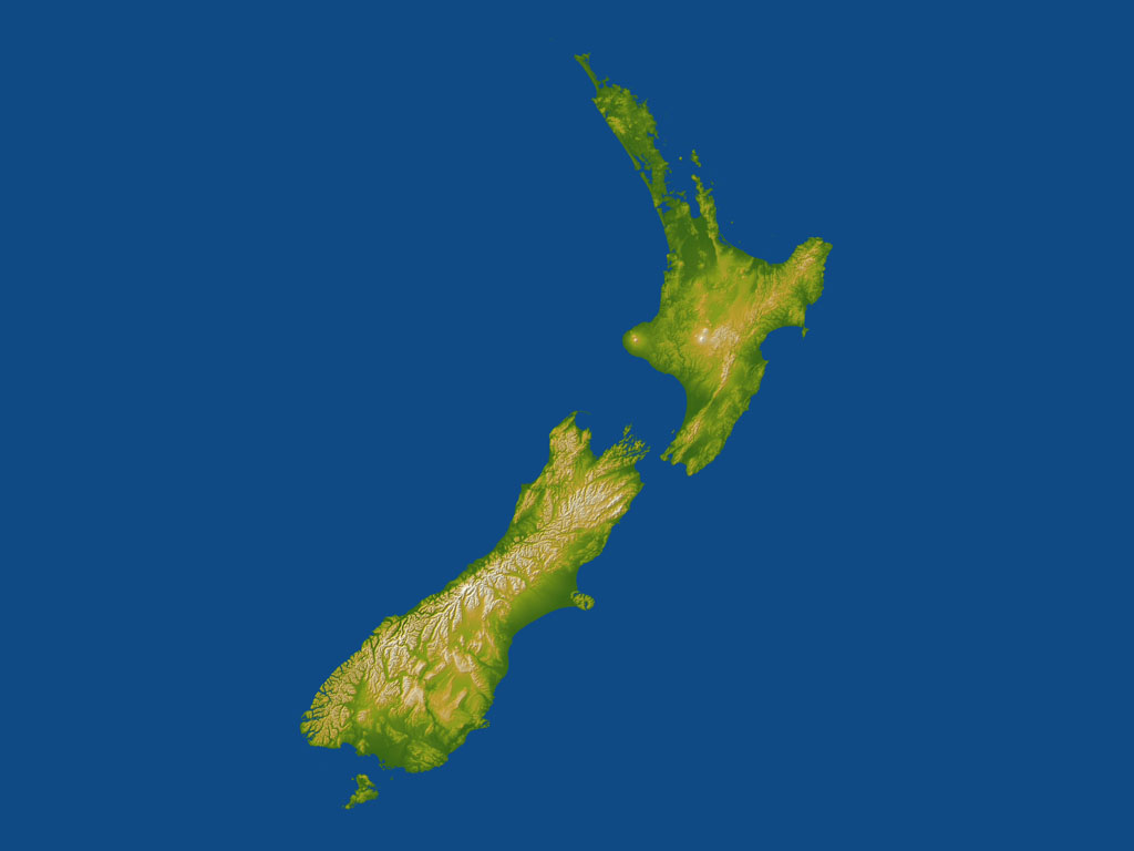
Pasadena CA (JPL) Jan 07, 2005 Culminating more than four years of processing data, NASA and the National Geospatial-Intelligence Agency have completed Earth's most extensive global topographic map. The data, extensive enough to fill the U.S. Library of Congress, were gathered during the Shuttle Radar Topography Mission, which flew in February 2000 on the Space Shuttle Endeavour. The digital elevation maps encompass 80 percent of Earth's landmass. They reveal for the first time large, detailed swaths of Earth's topography previously obscured by persistent cloudiness. The data will benefit scientists, engineers, government agencies and the public with an ever-growing array of uses. "This is among the most significant science missions the Shuttle has ever performed, and it's probably the most significant mapping mission of any single type ever," said Dr. Michael Kobrick, mission project scientist at NASA's Jet Propulsion Laboratory, Pasadena, Calif. The final data release covers Australia and New Zealand in unprecedented uniform detail. It also covers more than 1,000 islands comprising much of Polynesia and Melanesia in the South Pacific, as well as islands in the South Indian and Atlantic oceans. "Many of these islands have never had their topography mapped," Kobrick said. "Their low topography makes them vulnerable to tidal effects, storm surges and long-term sea level rise. Knowing exactly where rising waters will go is vital to mitigating the effects of future disasters such as the Indian Ocean tsunami." Data from the Shuttle Radar Topography Mission are being used for applications ranging from land use planning to "virtual" Earth exploration. "Future missions using similar technology could monitor changes in Earth's topography over time, and even map the topography of other planets," said Dr. John LaBrecque, manager of NASA's Solid Earth and Natural Hazards Program, NASA Headquarters, Washington, D.C. The mission's radar system mapped Earth from 56 degrees south to 60 degrees north of the equator. The resolution of the publicly available data is three arc-seconds (1/1,200th of a degree of latitude and longitude, about 295 feet, at Earth's equator). The mission is a collaboration among NASA, the National Geospatial- Intelligence Agency, and the German and Italian space agencies. The mission's role in space history was honored with a display of the mission's canister and mast antenna at the Smithsonian Institution's Udvar-Hazy Center, Chantilly, Va. To view a selection of new images from the Shuttle Radar Topography Mission's latest data set on the Internet, visit here. To view a new fly-over animation of New Zealand on the Internet, visit here. Community Email This Article Comment On This Article Related Links NASA SpaceDaily Search SpaceDaily Subscribe To SpaceDaily Express Earth Observation News - Suppiliers, Technology and Application
 New York NY (SPX) Jan 11, 2006
The importance of remotely sensed data and technologies to support natural disasters has prompted attention and action in Washington. New initiatives and legislation authorizing appropriations to the remote sensing industry will be discussed at Strategic Research Institute's U.S. Commercial Remote Sensing Industry conference, scheduled for February 9-10, 2006 in Washington D.C. |
|
| The content herein, unless otherwise known to be public domain, are Copyright 1995-2006 - SpaceDaily.AFP and UPI Wire Stories are copyright Agence France-Presse and United Press International. ESA PortalReports are copyright European Space Agency. All NASA sourced material is public domain. Additionalcopyrights may apply in whole or part to other bona fide parties. Advertising does not imply endorsement,agreement or approval of any opinions, statements or information provided by SpaceDaily on any Web page published or hosted by SpaceDaily. Privacy Statement |

