|
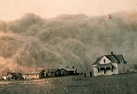
Greenbelt - Mar 18, 2004 NASA scientists have an explanation for one of the worst climatic events in the history of the United States, the "Dust Bowl" drought, which devastated the Great Plains and all but dried up an already depressed American economy in the 1930's. Siegfried Schubert of NASA's Goddard Space Flight Center, Greenbelt, Md., and colleagues used a computer model developed with modern-era satellite data to look at the climate over the past 100 years. The study found cooler than normal tropical Pacific Ocean surface temperatures combined with warmer tropical Atlantic Ocean temperatures to create conditions in the atmosphere that turned America's breadbasket into a dust bowl from 1931 to 1939. The team's data is in this week's Science magazine. These changes in sea surface temperatures created shifts in the large-scale weather patterns and low level winds that reduced the normal supply of moisture from the Gulf of Mexico and inhibited rainfall throughout the Great Plains. "The 1930s drought was the major climatic event in the nation's history," Schubert said. "Just beginning to understand what occurred is really critical to understanding future droughts and the links to global climate change issues we're experiencing today," he said. By discovering the causes behind U.S. droughts, especially severe episodes like the Plains' dry spell, scientists may recognize and possibly foresee future patterns that could create similar conditions. For example, La Ni�as are marked by cooler than normal tropical Pacific Ocean surface water temperatures, which impact weather globally, and also create dry conditions over the Great Plains. The researchers used NASA's Seasonal-to-Interannual Prediction Project (NSIPP) atmospheric general circulation model and agency computational facilities to conduct the research. The NSIPP model was developed using NASA satellite observations, including; Clouds and the Earth's Radiant Energy System radiation measurements; and the Global Precipitation Climatology Project precipitation data. The model showed cooler than normal tropical Pacific Ocean temperatures and warmer than normal tropical Atlantic Ocean temperatures contributed to a weakened low-level jet stream and changed its course. The jet stream, a ribbon of fast moving air near the Earth's surface, normally flows westward over the Gulf of Mexico and then turns northward pulling up moisture and dumping rain onto the Great Plains. As the low level jet stream weakened, it traveled farther south than normal. The Great Plains dried up and dust storms formed. The research shed light on how tropical sea surface temperatures can have a remote response and control over weather and climate. It also confirmed droughts can become localized based on soil moisture levels, especially during summer. When rain is scarce and soil dries, there is less evaporation, which leads to even less precipitation, creating a feedback process that reinforces lack of rainfall. The study also shed light on droughts throughout the 20th century. Analysis of other major U.S. droughts of the 1900s suggests a cool tropical Pacific was a common factor. Schubert said simulating major events like the 1930s drought provides an excellent test for computer models. While the study finds no indication of a similar Great Plains drought in the near future, it is vital to continue studies relating to climate change. NASA's current and planned suite of satellite sensors is uniquely poised to answer related climate questions. Community Email This Article Comment On This Article Related Links More at Goddard SpaceDaily Search SpaceDaily Subscribe To SpaceDaily Express Earth Observation News - Suppiliers, Technology and Application
 New York NY (SPX) Jan 11, 2006
The importance of remotely sensed data and technologies to support natural disasters has prompted attention and action in Washington. New initiatives and legislation authorizing appropriations to the remote sensing industry will be discussed at Strategic Research Institute's U.S. Commercial Remote Sensing Industry conference, scheduled for February 9-10, 2006 in Washington D.C. |
|
| The content herein, unless otherwise known to be public domain, are Copyright 1995-2006 - SpaceDaily.AFP and UPI Wire Stories are copyright Agence France-Presse and United Press International. ESA PortalReports are copyright European Space Agency. All NASA sourced material is public domain. Additionalcopyrights may apply in whole or part to other bona fide parties. Advertising does not imply endorsement,agreement or approval of any opinions, statements or information provided by SpaceDaily on any Web page published or hosted by SpaceDaily. Privacy Statement |