|
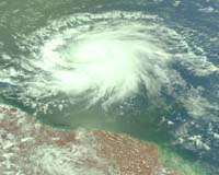
Pasadena CA (SPX) Nov 02, 2007 As Tropical Storm Noel churns off Florida's east coast, NASA and university scientists have announced they have developed a promising new technique for estimating the intensity of tropical cyclones from space. The method could one day supplement existing techniques, assist in designing future tropical cyclone satellite observing systems, and improve disaster preparedness and recovery efforts. The technique uses NASA satellite data, including simultaneous, accurate measurements of cloud-top temperatures from the Moderate Resolution Imaging Spectroradiometer on NASA's Aqua satellite, and cloud-top height and cloud profiling information from NASA's CloudSat satellite. Both satellites fly in formation as part of NASA's "A-Train" of Earth-observing satellites. This new technique was developed by scientists at NASA's Jet Propulsion Laboratory, Pasadena, Calif.; Colorado State University, Fort Collins, Colo.; and the Massachusetts Institute of Technology, Cambridge, Mass. Scientists commonly use measurements of a tropical cyclone's maximum sustained winds to define their intensity and gauge their destructive potential. Maximum sustained winds are defined as the one-minute average wind speed at an altitude of 10 meters (33 feet). The framework used by the team to estimate tropical cyclone intensity was developed by co-author Kerry Emanuel of the Massachusetts Institute of Technology and his colleague Valerie Wong. It requires cloud profiling information from over or near a storm's eye. Of the more than 150 tropical cyclones that CloudSat flew over during its first six months after launch in April 2006, nine of the storm overpasses met this criterion. The team analyzed NASA satellite data from these nine storms and calculated their peak winds. The estimates were then compared with available weather data, including data from aircraft. Initial results show the technique's estimates agreed with available weather data, and the technique appeared to work better for stronger storms. Emanuel and Wong's framework measures the intensity of tropical cyclones in relation to the total energy contained in both their eyewalls and the surrounding environment outside the storms, as well as other measurements. By coupling measurements of temperatures and cloud top heights from a storm's eyewall out to its outer regions with an estimated difference in temperature between the sea surface and the storm's cloud tops, a storm's intensity can be estimated. "Our study represents a unique and first-of-a-kind test of a hurricane intensity theory that had not been verified against real-world data, one that relies on actual satellite data," said lead study author Zhengzhao "Johnny" Luo, now with the City College of New York. "While our analysis is not yet mature enough for this technique to be used operationally, we plan to further refine it as more tropical cyclone data become available." Meteorological satellites have been used to monitor tropical cyclones since the mid 1960s. Relating measurements of storm intensity to existing satellite data has proven difficult. The primary technique used since the mid 1970s, developed by Vernon Dvorak of the National Oceanic and Atmospheric Administration, estimates a storm's maximum sustained winds by looking for recognizable patterns of clouds in visible and infrared satellite images and calibrating them against reconnaissance aircraft data. CloudSat Principal Investigator and study co-author Graeme Stephens of Colorado State University, Fort Collins, Colo., said the latest results show the value of being able to look inside storms to reveal their inner structure. This information is unique to CloudSat. "Current hurricane intensity estimating techniques are generally effective but have higher wind speed errors than scientists would like," he said. "This new technique may reduce those error rates." Community Email This Article Comment On This Article Related Links CloudSat Moderate Resolution Imaging Spectroradiometer Earth Observation News - Suppiliers, Technology and Application
 Guildford UK (SPX) Oct 28, 2007
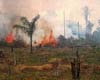
The Brazilian National Institute for Space Research (INPE) has placed a contract for a third year with DMC International Imaging Ltd., (DMCii) to acquire high-resolution satellite images of the entire 5 million square kilometres of the Amazon rainforest. Since 2004 INPE's programme to monitor deforestation has dramatically reduced the rate of logging from 27,000 sq.km. per year to about 10,000 sq.km. in 2007. |
|
| The content herein, unless otherwise known to be public domain, are Copyright 1995-2007 - SpaceDaily.AFP and UPI Wire Stories are copyright Agence France-Presse and United Press International. ESA Portal Reports are copyright European Space Agency. All NASA sourced material is public domain. Additional copyrights may apply in whole or part to other bona fide parties. Advertising does not imply endorsement,agreement or approval of any opinions, statements or information provided by SpaceDaily on any Web page published or hosted by SpaceDaily. Privacy Statement |