 |
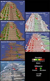
Washington DC (SPX) Sep 21, 2005 Through a cooperative research program NASA, the U.S. Geological Survey and the U.S. Army Corps of Engineers are exploring the use of innovative airborne laser mapping systems to quantify coastal change along the entire coastline affected by Hurricane Katrina. Elevation data from these research instruments acquired before and after the hurricane are compared to determine the patterns and magnitudes of coastal change caused by erosion and destruction of buildings and infrastructure. Three lidar surveys were collected using two different systems. The systems were NASA's Experimental Airborne Research Lidar (EAARL) and Army Corps of Engineers' Compact Hydrographic Airborne Rapid Total Survey (CHARTS). The impact of Hurricane Katrina was observed on Dauphin Island. Dauphin Island is a barrier island approximately 90 miles from where the storm made landfall. Storm surge inundated the island and waves transported sand landward into fan-shaped deposits shifting the entire island toward the coastline. A number of houses, depicted in the lidar difference plots as red rectangles, were destroyed. NASA has created a series of animations comparing the differences between the before and after elevation data sets that represent findings from the research on how major storm events can impact and change coastal areas. Community Email This Article Comment On This Article Related Links SpaceDaily Search SpaceDaily Subscribe To SpaceDaily Express Earth Observation News - Suppiliers, Technology and Application
 New York NY (SPX) Jan 11, 2006
The importance of remotely sensed data and technologies to support natural disasters has prompted attention and action in Washington. New initiatives and legislation authorizing appropriations to the remote sensing industry will be discussed at Strategic Research Institute's U.S. Commercial Remote Sensing Industry conference, scheduled for February 9-10, 2006 in Washington D.C. |
|
| The content herein, unless otherwise known to be public domain, are Copyright 1995-2006 - SpaceDaily.AFP and UPI Wire Stories are copyright Agence France-Presse and United Press International. ESA PortalReports are copyright European Space Agency. All NASA sourced material is public domain. Additionalcopyrights may apply in whole or part to other bona fide parties. Advertising does not imply endorsement,agreement or approval of any opinions, statements or information provided by SpaceDaily on any Web page published or hosted by SpaceDaily. Privacy Statement |
