|
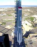
Vandenberg AFB CA (SPX) May 05, 2005 NASA is set to launch the new National Oceanic and Atmospheric Administration (NOAA) Polar-orbiting Operational Environmental Satellite (POES), another critical link in the development of a global Earth-observation program. The spacecraft, NOAA-N, will lift off at 6:22 a.m. EDT, May 11, 2005, from Vandenberg Air Force Base, Calif. "The NOAA-N satellite is key to establishing a strong Global Earth Observation System of Systems, because it will strengthen our understanding about what the environment around the world is doing, not just here in the U.S.," said Gregory Withee, assistant administrator for NOAA's Satellite and Information Service. "From monitoring the ash clouds of Mount St. Helens, to bolstering the U.S. search and rescue network, NOAA-N will be the link in our continued success," he added. NOAA-N will replace NOAA-16, in operation since September 2000, and join NOAA-17, launched in June 2002. Once in orbit, NOAA-N will be renamed NOAA-18. NOAA maintains a constellation of two primary polar-orbiting satellites. The global data from these satellites are used extensively in NOAA's weather and climate prediction models. "NASA is proud of our role in building and launching these satellites which contribute to NOAA's vital mission of providing weather forecasts and collecting environmental data about the Earth," said Karen Halterman, NASA POES Project Manager, at the Goddard Space Flight Center. As it orbits the globe, NOAA-N will collect data about the Earth's surface and atmosphere that are input for NOAA's long-range climate and seasonal outlooks, including forecasts for El Nino and La Nina. NOAA-N also has instruments used in the international Search and Rescue Satellite-Aided Tracking System, called COSPAS-SARSAT, which was established in 1982. NOAA polar-orbiting satellites detect emergency beacon distress signals and relay their location to ground stations, so rescue can be dispatched. SARSAT is credited with saving approximately 5,000 lives in the U.S. and more than 18,000 worldwide. NOAA-N is the fifteenth in a series of polar-orbiting satellites dating back to 1978. NOAA-N has imaging and sounding capabilities that are broadcast around the world and recorded on board for playback over NOAA ground stations. There is one more satellite in this series scheduled for launch in December 2007. NOAA's next generation of polar spacecraft, the National Polar-Orbiting Operational Environmental Satellite System (NPOESS), is planned for launch in early 2010. NPOESS is a combined program with NOAA, the Department of Defense and NASA. NOAA manages the POES program and establishes requirements, provides all funding and distributes environmental satellite data for the United States. NASA's Goddard Space Flight Center procures and manages the development and launch of the satellites for NOAA on a cost-reimbursable basis. Twenty-one days after the satellite is launched, NASA will transfer operational control to NOAA. NASA's comprehensive on-orbit verification period is expected to last approximately 45 days after launch. Community Email This Article Comment On This Article Related Links NASA's GOES POES Program SpaceDaily Search SpaceDaily Subscribe To SpaceDaily Express Earth Observation News - Suppiliers, Technology and Application
 New York NY (SPX) Jan 11, 2006
The importance of remotely sensed data and technologies to support natural disasters has prompted attention and action in Washington. New initiatives and legislation authorizing appropriations to the remote sensing industry will be discussed at Strategic Research Institute's U.S. Commercial Remote Sensing Industry conference, scheduled for February 9-10, 2006 in Washington D.C. |
|
| The content herein, unless otherwise known to be public domain, are Copyright 1995-2006 - SpaceDaily.AFP and UPI Wire Stories are copyright Agence France-Presse and United Press International. ESA PortalReports are copyright European Space Agency. All NASA sourced material is public domain. Additionalcopyrights may apply in whole or part to other bona fide parties. Advertising does not imply endorsement,agreement or approval of any opinions, statements or information provided by SpaceDaily on any Web page published or hosted by SpaceDaily. Privacy Statement |