|
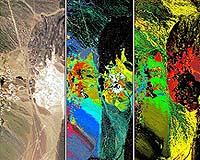
Washington (SPX) May 04, 2005 Can you see the difference between traditional corn and bio-engineered corn? NASA technology is beginning to provide the answer in a snapshot. The technology is called hyperspectral imaging. It uses a special camera to cut one snapshot into 120 color-specific images. Hyperspectral means getting many more images within the spectrum of just one picture. Each image shows a unique characteristic not visible to the human eye. The hyperspectral camera and its applications were developed by the Institute for Technology Development at NASA's Stennis Space Center. The Institute is one of several NASA Research Partnership Centers managed by the agency's Marshall Space Flight Center. The Environmental Protection Agency (EPA) teamed with NASA to use the technology to ensure appropriate management practices are used to avoid the development of resistance in corn pest populations. Pest resistance could severely limit the continued use of these new varieties of corn. With more than 25 million acres of corn planted this year, it is physically and economically infeasible to sample each one. This new technology seeks to provide an active monitoring capability to inform the grower of pest resistance development. Early use of hyperspectral imaging provides the ability to distinguish between the two types of corn and identify pest infestation conditions. Bio-engineered corn has inserted genes to make the plant resistant to insects. The EPA is using a small hyperspectral camera mounted on an aircraft. The aircraft flies at approximately 8,000 feet, imaging the same sites every 10 days during growing season. The images are put into a computer system, and data-mining techniques are used to extract information about the corn. "This effort will enhance NASA's understanding of image processing techniques to extract knowledge from hyperspectral data sets," said Brian Mitchell of NASA's Space Partnership Development Program at Marshall. "The research being conducted with genetically modified plants and plant growth has the potential to contribute significantly in our ability to grow sustainable and nutritional crops in space. This could prove vital for long duration exploration missions." The hyperspectral technology supports the Vision for Space Exploration and long-term spaceflight goals. The Vision calls for returning the Space Shuttle to safe flight, completing the International Space Station, human and robotic exploration of the Solar System. "This knowledge is vital to future Mars missions," said George May, director of the Institute for Technology Development. "When we go to Mars, we will have to grow our own food. This technology enables early detection of stresses in plants, such as nutrient problems, so corrective action can be taken to maintain the food supply." Hyperspectral imaging may be used to treat crew injuries in space. The Institute is working on a portable, handheld camera to take images of a wound site. Using that image to identify wound severity and healing progress will allow doctors to decide the best treatment. The imaging could save precious diagnostic time, which would also improve healing by ensuring timely and proper treatment. Hyperspectral imaging will also detect mold and toxins in spacecraft, a needed tool during long-duration missions to ensure crews have a clean, healthy environment. The patented, portable hyperspectral sensor was inducted into the Space Foundation's Space Technology Hall of Fame in April. Community Email This Article Comment On This Article Related Links Institute for Technology Development at Stennis U.S. Environmental Protection Agency SpaceDaily Search SpaceDaily Subscribe To SpaceDaily Express Earth Observation News - Suppiliers, Technology and Application
 New York NY (SPX) Jan 11, 2006
The importance of remotely sensed data and technologies to support natural disasters has prompted attention and action in Washington. New initiatives and legislation authorizing appropriations to the remote sensing industry will be discussed at Strategic Research Institute's U.S. Commercial Remote Sensing Industry conference, scheduled for February 9-10, 2006 in Washington D.C. |
|
| The content herein, unless otherwise known to be public domain, are Copyright 1995-2006 - SpaceDaily.AFP and UPI Wire Stories are copyright Agence France-Presse and United Press International. ESA PortalReports are copyright European Space Agency. All NASA sourced material is public domain. Additionalcopyrights may apply in whole or part to other bona fide parties. Advertising does not imply endorsement,agreement or approval of any opinions, statements or information provided by SpaceDaily on any Web page published or hosted by SpaceDaily. Privacy Statement |