|
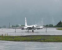
Greenbelt MD (SPX) Dec 20, 2006 Hurricanes not only threaten lives and property, they also often behave erratically, with seemingly endless shifts in intensity and movement that have long challenged forecasters. But new research using sophisticated weather research tools is shedding new light on the nature of these fickle storms. Flying over Hurricane Dennis in July 2005 - a category 4 hurricane - with NASA's ER-2 aircraft and the National Oceanic and Atmospheric Administration's (NOAA) P-3 aircraft, scientists took measurements of the storm's internal structure. The information is giving clues about the evolution of a hurricane's warm inner core and the factors related to its formation. Joe Turk, Steve Miller, and Jeff Hawkins of the Naval Research Laboratory, Monterey, Calif., and Steve Guimond of Florida State University, Tallahassee, Fla., will present their findings today at the American Geophysical Union's 2006 Fall Meeting in San Francisco. The research flights were conducted as part of the Tropical Cloud Systems and Processes (TCSP) mission in Costa Rica, a NASA field experiment with cooperative participation from NOAA and several universities. This experiment was aimed at studying the birthing conditions for tropical storms and hurricanes and identifying the factors that cause them to strengthen or weaken. "This campaign was particularly unique because two types of aircraft provided measurements on different atmospheric variables," said Turk. "The information is also being used to determine how accurately satellites capture storm details." While a few satellites can now look through clouds, the aircraft data provide a level of detail far superior to satellites. Dennis reached hurricane strength on July 7, 2005, in the eastern Caribbean Sea, and rapidly strengthened into a category 4 storm before making landfall in Cuba on July 8. After weakening over land, Dennis quickly re-intensified over the Gulf of Mexico before weakening again prior to its second landfall in Florida. As the storm fluctuated in intensity, flights into the storm continued, taking critical measurements of wind, rainfall, temperature, and moisture. "The erratic nature of the storm and the timing of the research mission allowed scientists to pierce through the core of the hurricane at many stages of its life cycle and for the first time map a hurricane's entire evolution," said Guimond. NASA's ER-2 Doppler radar measured wind speed along the track of the aircraft including measurements indicative of the size and concentration of raindrops and ice particles, while another ER-2 instrument, the Advanced Microwave Precipitation Radiometer, gathered microwave imagery of the internal structure of rain clouds. By analyzing when and where strong winds are occurring, researchers can better determine when intensity changes may occur. Data on the storm's vertical temperature structure - indirectly related to wind speed and rainfall - was also examined from overpasses of NOAA satellites. Previous research has suggested that rapid hurricane intensification, like that seen in Dennis, is linked to hot towers, rain clouds that reach at least the top of troposphere - the lowest layer of the atmosphere - and about nine miles high in the tropics. They are called "hot" because of the large amount of latent heat they release, fuel for strong winds and heavy rainfall. "With Dennis, it appears the hot towers played a major role in the rapid intensification of the storm, giving clues on how energy is concentrated and winds evolve at various stages of development," said Guimond. "The observations also helped place the storm's behavior in greater context and matched well with computer model simulations, suggesting that we are making progress in replicating hurricane development." While meteorologists have made considerable strides in forecasting a hurricane's track, intensity predictions have remained a more significant challenge. Part of the difficulty is that the many factors that control intensity, particularly the speed, direction and spin of air throughout the atmosphere, are constantly changing and difficult to measure. Community Email This Article Comment On This Article Related Links NASA ER-2 research aircraft NOAA P-3 feature A world of storm and tempest Bringing Order To A World Of Disasters When the Earth Quakes A world of storm and tempest
British scientists studying a large fault zone in northern Chile say they've gained insight into how fluid pressure can cause earthquakes. |
|
| The content herein, unless otherwise known to be public domain, are Copyright 1995-2006 - SpaceDaily.AFP and UPI Wire Stories are copyright Agence France-Presse and United Press International. ESA PortalReports are copyright European Space Agency. All NASA sourced material is public domain. Additionalcopyrights may apply in whole or part to other bona fide parties. Advertising does not imply endorsement,agreement or approval of any opinions, statements or information provided by SpaceDaily on any Web page published or hosted by SpaceDaily. Privacy Statement |