|
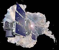
Greenbelt MD (SPX) Nov 21, 2005 NASA's Ice, Cloud and land Elevation Satellite (ICESat) fired its one billionth laser shot earthward on Nov. 18, to obtain elevations from objects on the land, sea and in the air. ICESat measures the Earth's polar ice sheets, clouds, mountains and forests with three lasers. Crisscrossing the globe at nearly 17,000 miles per hour, ICESat provides unprecedented accuracy in mapping Earth's vertical characteristics, enabling scientists to see objects on Earth in three dimensions. The principal mission of ICESat is to measure the surface elevation of the large ice sheets covering Antarctica and Greenland. Measurements of elevation-change over time will show whether the ice sheets are melting or growing as the Earth's climate undergoes natural and human-induced changes. The instrument on ICESat that makes the claim is the Geoscience Laser Altimeter System (GLAS) instrument. GLAS fired its one billionth shot last Friday morning, November 18. "One billion shots equal one billion elevation measurements around the world of land, sea clouds, etc." said Waleed Abdalati, head of the Cryospheric Sciences Branch, Hydrospheric and Biospheric Sciences Laboratory, at NASA's Goddard Space Flight Center, Greenbelt, Md. "That number tops the 6.5 million shots from Mars Orbiter Laser Altimeter, an instrument currently in orbit around Mars on the Mars Global Surveyor spacecraft," he said. GLAS sends short pulses of green and infrared light though the sky 40 times a second, all over the globe, and collects the reflected laser light with a one-meter telescope. It also fires a fine laser beam of light that spreads out as it approaches the Earth's surface, to about 65 meters in diameter. On its way to the surface, those photons or particles of light bounce off clouds, aerosols, ice, leaves, ocean, land and more, providing detailed information on the vertical structure of the earth system. ICESat was launched on January 3, 2003 from the Vandenberg Air Force Base, Calif. Community Email This Article Comment On This Article Related Links ICESat at NASA SpaceDaily Search SpaceDaily Subscribe To SpaceDaily Express Earth Observation News - Suppiliers, Technology and Application
 New York NY (SPX) Jan 11, 2006
The importance of remotely sensed data and technologies to support natural disasters has prompted attention and action in Washington. New initiatives and legislation authorizing appropriations to the remote sensing industry will be discussed at Strategic Research Institute's U.S. Commercial Remote Sensing Industry conference, scheduled for February 9-10, 2006 in Washington D.C. |
|
| The content herein, unless otherwise known to be public domain, are Copyright 1995-2006 - SpaceDaily.AFP and UPI Wire Stories are copyright Agence France-Presse and United Press International. ESA PortalReports are copyright European Space Agency. All NASA sourced material is public domain. Additionalcopyrights may apply in whole or part to other bona fide parties. Advertising does not imply endorsement,agreement or approval of any opinions, statements or information provided by SpaceDaily on any Web page published or hosted by SpaceDaily. Privacy Statement |