|
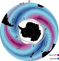
Hobart - Jul 25, 2003 Australian scientists have found a new way to measure the strength of the world's largest ocean current system and one of the key drivers of the world's climate - the Antarctic Circumpolar Current. The technique uses very precise satellite measurements of changes in sea surface height to detect changes in deep ocean currents. "What's exciting about this research is that we can get a new measurement of the current every 10 days from the satellite," says oceanographer Dr Steve Rintoul from the Antarctic Climate and Ecosystems Cooperative Research Centre and CSIRO. "This will allow us for the first time to determine how these important currents vary with time and what impact they have on the climate. "The Circumpolar Current acts like a huge pipe or canal carrying water and heat between the ocean basins so to understand how the ocean influences climate, both today and in the future, we need to monitor this key link in the global pattern of ocean currents that control climate," says Dr Rintoul. "Changes in the flow of the current are likely to influence regional and global climate patterns. But this hypothesis has been difficult to test because we have so few observations of the currents in the Southern Ocean," he says. "Most of our ocean measurements come from ships, and ships tend to avoid the remote and hostile Southern Ocean." The volume of Antarctic Circumpolar Current passing between Tasmania and the Antarctic is equivalent to 150 times the flow of all the world's rivers to the sea. While satellites have been used to study ocean currents for more than a decade, this is the first time that such measurements have been used to monitor the massive flow of the Antarctic Circumpolar Current. Oceanographers usually measure the strength of ocean currents by obtaining profiles of temperature and salinity from an instrument lowered from a ship. Dr Rintoul and his colleagues, Dr Serguei Sokolov and Dr John Church, at CSIRO have used ship-based observations collected over the last decade to calibrate a simple index of current strength based on sea levels measured by satellite. Using this relationship, changes in the height of the sea surface can be translated into changes in the amount of water flowing between Tasmania and Antarctica. Southern Ocean research is supported by the Federal Government through organisations including the Australian Greenhouse Office. The study relied on data collected over the last decade by partners from Australia, France, and the USA. The satellite altimeter data used comes from the joint US-France mission Topex/Poseidon and the European Space Agency. Community Email This Article Comment On This Article Related Links SpaceDaily Search SpaceDaily Subscribe To SpaceDaily Express Dirt, rocks and all the stuff we stand on firmly
 Bangkok (AFP) Dec 9, 2005
Environmental damage threatens human health and may have contributed to the spread of new diseases like bird flu and SARS, the World Health Organization said in a report Friday. |
|
| The content herein, unless otherwise known to be public domain, are Copyright 1995-2006 - SpaceDaily.AFP and UPI Wire Stories are copyright Agence France-Presse and United Press International. ESA PortalReports are copyright European Space Agency. All NASA sourced material is public domain. Additionalcopyrights may apply in whole or part to other bona fide parties. Advertising does not imply endorsement,agreement or approval of any opinions, statements or information provided by SpaceDaily on any Web page published or hosted by SpaceDaily. Privacy Statement |