|
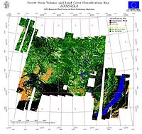
Paris - Oct. 26, 2000 Three years ago, two containers with equipment for a mobile receiving station set off for Mongolia to begin one of the biggest remote-sensing campaigns ever undertaken in Europe: to image an area of global ecological importance, the central-Siberian forest, using three Earth Observation radar satellites. The new map of the Siberian forest is being presented this week at DLR in Munich. Known as the SIBERIA project (SAR Imaging for Boreal Ecology and Radar Interferometry Applications), this huge undertaking used the combined forces of the German Aerospace Centre (DLR), the European Space Agency (ESA), and the Japanese Space Agency (NASDA). Data from three satellites -- ESA's ERS-1 and -2 and and Japan's JERS-1 were collected simultaneously throughout autumn 1997 and then again in summer 1998. These data were used in one of the most extensive remote sensing projects (1.2 Million sq km) ever undertaken to demonstrate the operational use of radar remote-sensing for very large-area forest mapping. The resulting map will help the Russian forestry authorities to update obsolete forest inventory data and to monitor reforestation, for example after forest fires. "Working with our forest partners in Russia has been mutually rewarding," says Christiane Schmullius, the SIBERIA project co-ordinator for ten European and four Russian institutions. 550 ERS-scenes plus 890 JERS-1 scenes were used to produce one of the world's most extensive forest cover maps. The main source of information was a special radar mode known as ERS tandem interferometry. This uses ERS-1 and �2 in a dedicated orbit configuration that allows images of a particular area to be taken two days' running. The project team met at the German Aerospace Centre DLR near Munich on 26/27 October 2000 to present the 7.5 m x 5.5 m wall map and the associated results. The SIBERIA project was funded by the European Commission within the 4th European Framework Programme via its Centre of Earth Observation. The ERS data were provided by ESA/ESRIN in the framework of the ERS Announcement of Opportunity (see links). Community Email This Article Comment On This Article Related Links SIBERIA Project homepage EO Exploitation Projects ERS AO3 Earth Observation Homepage SpaceDaily Search SpaceDaily Subscribe To SpaceDaily Express Dirt, rocks and all the stuff we stand on firmly
 Paris (ESA) Jan 12, 2006
Using the ESA Cluster spacecraft and the NASA Wind and ACE satellites, a team of American and European scientists have discovered the largest jets of particles created between the Earth and the Sun by magnetic reconnection. This result makes the cover of this week's issue of Nature. |
|
|
|
|
|
|
|
|
|
|
|
|
|
| The content herein, unless otherwise known to be public domain, are Copyright 1995-2006 - SpaceDaily.AFP and UPI Wire Stories are copyright Agence France-Presse and United Press International. ESA PortalReports are copyright European Space Agency. All NASA sourced material is public domain. Additionalcopyrights may apply in whole or part to other bona fide parties. Advertising does not imply endorsement,agreement or approval of any opinions, statements or information provided by SpaceDaily on any Web page published or hosted by SpaceDaily. Privacy Statement |