|
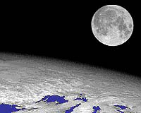
Sydney - August 22, 2001 For the first time, CSIRO and US scientists are using the moon to check and calibrate sensors on board weather satellites. The 'moon tuned' sensors are expected to provide a wealth of improved information about climate change and air pollution. "The moon is the perfect object to point the satellite sensors at in order to check them," says Dr Ian Grant from CSIRO Atmospheric Research. "The moon's surface is bare and unchanging and there is no air between it and the satellite." In the past, scientists have calibrated satellite sensors by checking their views of uniform targets on Earth, such as deserts or clouds. However, the atmosphere gets in the way and vegetation and rainfall can alter the appearance of deserts. "We are doing lunar calibrations with the imager on the Japanese Geostationary Meteorological Satellite. This is the imager that gives us the pictures of clouds over Australia that we see on TV weather reports," says Dr Grant. Although the moon's surface is unchanging, the brightness of any point on the moon changes with the direction of sunlight and the direction from which the satellite looks. The US Geological Survey accurately maps the moon's brightness from its lunar observatory in Arizona. The satellite imager is calibrated at times when its view of the moon matches the view angle of instruments at the observatory. "In future, we'll be able to check the imager from a range of viewing angles," says Dr Grant. Additionally, the newly calibrated satellite sensor will be able to more accurately monitor smoke plumes from large fires that are prevalent in the tropics. Climate scientists are especially interested in the way in which such smoke can affect global warming. Dr Grant presented this breakthrough in satellite imager calibration at a recent international remote sensing conference in Australia. He collaborated on the research with a team led by Dr Hugh Kieffer from the US Geological Survey. There are currently eight geostationary meteorological satellites in orbit, and the lunar technique could be used in future to calibrate all of them. This will make their data more consistent and accurate, and so better able to monitor global climate and smoke plumes. Community Email This Article Comment On This Article Related Links CSIRO Atmospheric Research SpaceDaily Search SpaceDaily Subscribe To SpaceDaily Express Dirt, rocks and all the stuff we stand on firmly
 Paris (ESA) Jan 12, 2006
Using the ESA Cluster spacecraft and the NASA Wind and ACE satellites, a team of American and European scientists have discovered the largest jets of particles created between the Earth and the Sun by magnetic reconnection. This result makes the cover of this week's issue of Nature. |
|
|
|
|
|
|
|
|
|
|
|
|
|
| The content herein, unless otherwise known to be public domain, are Copyright 1995-2006 - SpaceDaily.AFP and UPI Wire Stories are copyright Agence France-Presse and United Press International. ESA PortalReports are copyright European Space Agency. All NASA sourced material is public domain. Additionalcopyrights may apply in whole or part to other bona fide parties. Advertising does not imply endorsement,agreement or approval of any opinions, statements or information provided by SpaceDaily on any Web page published or hosted by SpaceDaily. Privacy Statement |