|
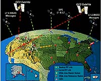
Rockville MD (SPX) Sep 12, 2005 A satellite that will enable future air navigation enhancements has been deployed for Lockheed Martin. The payload is the first use of the GPS L5 civil navigation frequency for the Federal Aviation Administration (FAA), and supports a move toward satellite-based navigation to make air traffic management safer, more reliable and more accurate. It also is the first deployment of this technology for civil aviation use in North America. Lockheed Martin contracted with satellite service providers Telesat and PanAmSat to host navigation payloads it will operate as part of the FAA's Wide Area Augmentation System (WAAS) Geostationary Communications and Control Segment (GCCS) initiative. The successful launch of the Telesat Anik F1R satellite from Baikonur Cosmodrome in the Republic of Kazakhstan is the first of the two GCCS payloads scheduled for deployment this year to support the program. The navigation payload on the Anik F1R satellite establishes a vital base for providing en route and vertical guidance to aircraft at thousands of North American airports and airstrips. "This is a significant step for the future of air navigation, and an essential part of next-generation air traffic control system," said Don Antonucci, president of Lockheed Martin Transportation and Security Solutions. "GCCS is a vital building block of WAAS-based broadcast services for aviation use � it adds additional user signals to improve system utility. These new satellites with improved orbital locations and increased transmit power affords our customer significantly increased availability of the WAAS service across the FAA's National Airspace System." Under the FAA's GCCS contract, Lockheed Martin and its teammates will provide ground uplink stations that receive global positioning system (GPS) correction and integrity data from the WAAS monitoring network, and broadcast the data to the geostationary communications satellites for delivery to users. In aviation use, a WAAS broadcast message allows an improvement of GPS-base position accuracy from 30 meters (100 feet) to approximately 7 meters (27 feet). This improved accuracy enables instrument landing operations at previously unsupported airfields. PanAmSat Corporation is scheduled to deliver the second L-band navigation payload to Lockheed Martin this fall. Lockheed Martin and the FAA will perform 12 months of segment and system level integration and test prior to the WAAS GCCS service going operational in September 2006. The FAA contract supporting these enhancements is valued at $314 million. Lockheed Martin was awarded this contract in 2003. Community Email This Article Comment On This Article Related Links Lockheed Martin SpaceDaily Search SpaceDaily Subscribe To SpaceDaily Express Aerospace News at SpaceMart.com
 Woodland Hills CA (SPX) Jan 12, 2006
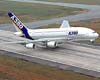
Lufthansa will be one of the first commercial air carriers worldwide to benefit from the latest air data inertial reference units from Northrop Grumman. Inertial reference units provide aircrews with essential aircraft operational data such as aircraft position, velocities, attitude, altitude, air speed and many other parameters. |
|
| The content herein, unless otherwise known to be public domain, are Copyright 1995-2006 - SpaceDaily.AFP and UPI Wire Stories are copyright Agence France-Presse and United Press International. ESA PortalReports are copyright European Space Agency. All NASA sourced material is public domain. Additionalcopyrights may apply in whole or part to other bona fide parties. Advertising does not imply endorsement,agreement or approval of any opinions, statements or information provided by SpaceDaily on any Web page published or hosted by SpaceDaily. Privacy Statement |