|
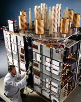
Cape Canaveral FL (SPX) Sep 27, 2006 A modernized Global Positioning System Block IIR (GPS IIR-M) satellite built by Lockheed Martin was launched successfully today from Cape Canaveral Air Force Station, Fla. The satellite, designated GPS IIR-15(M), is the second in a series of eight modernized GPS Block IIR spacecraft that Lockheed Martin Navigation Systems is developing for its customer, the Global Positioning Systems Wing, Space and Missile Systems Center, Los Angeles Air Force Base, Calif. The spacecraft are the most technologically advanced GPS satellites ever developed and are designed to provide significantly improved navigation performance for U.S. military and civilian users worldwide. The satellite will join the first modernized IIR satellite, GPS IIR-14(M), successfully launched and declared operational last year and 12 other operational Block IIR satellites currently on-orbit within the overall 29-spacecraft constellation. The Air Force dedicated today's mission to honor American POW/MIAs past and present. "We're proud of our partnership with the U.S. Air Force in delivering unparalleled navigation capabilities to GPS users around the globe," said Don DeGryse, Lockheed Martin's vice president of Navigation Systems. "We look forward to executing a successful on-orbit checkout so that this modernized spacecraft can be quickly placed into operational service." The GPS IIR-M spacecraft offer a variety of enhanced features for GPS users, such as a modernized antenna panel that provides increased signal power to receivers on the ground, two new military signals for improved accuracy, enhanced encryption and anti-jamming capabilities for the military, and a second civil signal that will provide users with an open access signal on a different frequency. The Global Positioning System enables properly equipped users to determine precise time and velocity and worldwide latitude, longitude and altitude to within a few meters. Air Force Space Command's 2nd Space Operations Squadron (2SOPS), based at Schriever Air Force Base, Colo., manages and operates the GPS constellation for both civil and military users. GPS IIR-M production takes place at Lockheed Martin facilities in Valley Forge, Pa. The modernized navigation payload is provided by ITT Industries in Clifton, N.J. Lockheed Martin is also leading a team competing to build the next-generation Global Positioning System, known as GPS Block III. The new program will address the challenging military transformational and civil needs across the globe, including advanced anti-jam capabilities and improved system security, accuracy and reliability. GPS Block III will enhance space-based navigation and performance and set a new world standard for positioning and timing services. Community Email This Article Comment On This Article Related Links GPS Applications, Technology and Suppliers GPS Applications, Technology and Suppliers
 St. Louis MO (SPX) Sep 27, 2006
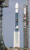
The reliable Boeing Delta II launch vehicle, known as the workhorse of the launch industry in its payload class, successfully delivered to orbit earlier today a replenishment Block IIR Global Positioning System (GPS) satellite for the U.S. Air Force. |
|
| The content herein, unless otherwise known to be public domain, are Copyright 1995-2006 - SpaceDaily.AFP and UPI Wire Stories are copyright Agence France-Presse and United Press International. ESA PortalReports are copyright European Space Agency. All NASA sourced material is public domain. Additionalcopyrights may apply in whole or part to other bona fide parties. Advertising does not imply endorsement,agreement or approval of any opinions, statements or information provided by SpaceDaily on any Web page published or hosted by SpaceDaily. Privacy Statement |