|
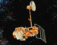
Reston VA (SPX) January 31, 2006 The USGS is pleased to announce Landsat 5 is back in operation. USGS and NASA engineers were able to make adjustments to operating procedures for the solar array drive mechanism that now allows the solar array to provide enough power for the mission to resume normal operations. Consequently, acquisition operations have begun over the conterminous U.S. and the international stations will be brought on line in the coming weeks. The solar array drive mechanism began exhibiting problems in late November 2005. The rotation of the solar array drive became sporadic and the solar array was not able to provide the power needed to charge the batteries. As a precaution, imaging operations were suspended until the problem was identified and potential solutions were evaluated and tested. "This is good news for the global science and operational communities, " said Mr. Jay Feuquay, Land Remote Sensing Program Coordinator for the USGS. "The Landsat Program has a well-established record of over 30 years of earth observations. The latest developments allow the Landsat user community to continue to rely on Landsat imagery. I am optimistic about the 'fix' applied to the solar array problem and the future operations of Landsat 5. At the same time, we are moving aggressively to develop a Landsat Data Continuity Mission that will provide Landsat data continuity." Landsat 5, launched in March 1984, has performed far beyond its three-year design lifetime and has continued to collect global land surface coverage. Over 620,000 images, illustrating events from the Chernobyl disaster to Hurricane Katrina, have proven invaluable for identifying the impact of natural and human-induced changes. Landsat 5 and Landsat 7 together provided full global coverage of the Earth's surface. The Landsat Program is the longest running civilian program providing vital images of the Earth's surface from space. The first Landsat satellite was launched in 1972 and since then, Landsat satellites have been providing a constant stream of moderate-resolution images. In 1999, the Landsat Program took a giant leap forward technologically with the launch of Landsat 7. The instruments on the Landsat satellites have acquired millions of images of the surface of the planet, providing a unique resource for scientists who study agriculture, geology, forestry, regional planning, education, mapping and global change research. The Landsat Program has been a joint initiative of USGS and NASA to gather Earth resource data using a series of satellites including Landsats 5 and 7. NASA is responsible for developing and launching the spacecrafts, while the USGS is responsible for flight operations, maintenance, and management of all data reception, processing, archiving, product generation, and distribution. The primary objective of the Landsat Program is to ensure a consistent, calibrated collection of Earth imagery that can be used to scientifically measure change over decades and beyond, and support the operational agencies. Landsat's global survey mission is to repeatedly capture images of the Earth's land mass, coastal boundaries, and coral reefs; and to ensure the data acquired are of maximum utility in supporting the objectives of monitoring changes in the Earth's land surface and associated environment. Community Email This Article Comment On This Article Related Links The Landsat Program Earth Observation News - Suppiliers, Technology and Application
 Tokyo, Japan (SPX) February 1, 2006
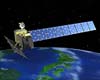
The Japan Aerospace Exploration Agency (JAXA) has confirmed that there was no problem in the data processing function of the Daichi, thus it carried out operations to have the Daichi return to normal operations until 11:54 a.m. on January 28, 2006 (Japan Standard Time, JST.) |
|
| The content herein, unless otherwise known to be public domain, are Copyright 1995-2006 - SpaceDaily.AFP and UPI Wire Stories are copyright Agence France-Presse and United Press International. ESA PortalReports are copyright European Space Agency. All NASA sourced material is public domain. Additionalcopyrights may apply in whole or part to other bona fide parties. Advertising does not imply endorsement,agreement or approval of any opinions, statements or information provided by SpaceDaily on any Web page published or hosted by SpaceDaily. Privacy Statement |