|
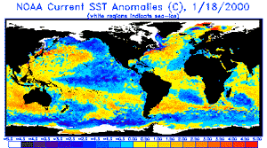
Pasadena - January 19 2000 - A giant horseshoe pattern of higher than normal sea surface heights developing over the last year is beginning to dominate the entire western Pacific and Asiatic oceans, new imagery from TOPEX. Scientists at NASA's Jet Propulsion Laboratory, Pasadena, Calif., studying the new data believe these abnormally warm ocean temperatures, which contrast with a cool La Nina, may be part of a larger, longer-lasting climate pattern. The latest data, taken December 30, 1999 through January 8, 2000, show that this slower-developing condition covers most of the Pacific Ocean and has significant implications for global climate change, especially over North America, said Dr. William Patzert, an oceanographer at JPL. "In contrast with the more spectacular but shorter duration El NiNo and La NiNa events, this multiple-year trend may be part of a decade-long pattern known as the 'Pacific decadal oscillation,'" Patzert said. "The persistence of these abnormally high and low Pacific sea-surface patterns, along with warmer and colder than average ocean temperatures, tells us there is much more than an isolated La Ni�a occurring in the Pacific Ocean." Satellite data from the National Oceanic and Atmospheric Administration clearly illustrate the pattern. Sea-surface temperatures, which directly affect the atmosphere on a daily basis are available and show the same warm and cool water patterns. "These warmer and cooler than normal sea-surface temperatures influence our atmosphere every day, while sea-surface heights are a measure of how much heat is stored in the ocean below," Patzert said. "When you put these two pieces of the climate puzzle together, they will tell us both about what is influencing today's weather and how much heat is being stored in the ocean to fuel future planetary climate events." The Pacific decadal oscillation waxes and wanes approximately every 20 to 30 years, alternating between its present phase, with a warm horseshoe pattern of higher than normal sea-surface heights connecting the north, west and southern Pacific, in contrast to a cool wedge of lower than normal sea-surface heights in the eastern equatorial Pacific. After that the Pacific switches to the opposite phase, showing a reversal of the warm and cool regions; the horseshoe becomes cool and the wedge warms.
The U.S.-French TOPEX/Poseidon mission is managed JPL for the NASA's Earth Science Enterprise, Washington, D.C. JPL is a division of the California Institute of Technology in Pasadena.
Email This Article Comment On This Article Related Links Space
 Calcutta, India (SPX) Dec 28, 2005
The successful launch Thursday of India's heaviest satellite from spaceport of Kourou in French Guyana may have boosted the country's space research efforts to yet another level, but it has also lifted the spirits of at least three Direct-To-Home televisions broadcasters, one of which has been waiting for years to launch its services in India. |
|
|
|
|
|
|
|
|
|
|
|
|
|
| The content herein, unless otherwise known to be public domain, are Copyright 1995-2006 - SpaceDaily.AFP and UPI Wire Stories are copyright Agence France-Presse and United Press International. ESA PortalReports are copyright European Space Agency. All NASA sourced material is public domain. Additionalcopyrights may apply in whole or part to other bona fide parties. Advertising does not imply endorsement,agreement or approval of any opinions, statements or information provided by SpaceDaily on any Web page published or hosted by SpaceDaily. Privacy Statement |