|
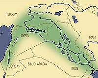
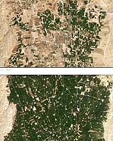
Greenbelt - Dec 01, 2003 High in the mountains of Turkey, ravines and gullies collect water that becomes the Tigris and Euphrates Rivers. Flowing southward to the Persian Gulf across southern Turkey, Syria, and Iraq, the rivers drip life into the arid terrain. This area of water in the desert is part of the Fertile Crescent, a swath of well-watered land that hugs the eastern coast of the Mediterranean Sea, peaks in southern Turkey, and trails southward through Mesopotamia�the land between rivers�in Syria and Iraq. This region gave birth to Middle Eastern civilization more than 8,000 years ago. Plant and animal domestication, irrigation, and new tools launched an agricultural revolution that transformed roaming hunter-gatherers into a socially complex, permanent society. Almost a hundred centuries later, another kind of agricultural revolution is underway in the northern part of the Fertile Crescent, this one due to a major infrastructure development in Turkey's Southeast Anatolia region that will provide irrigation to 1.7 million hectares (4.2 million acres) of new farmland. Among the most significant milestones of the project was the completion in 1994 of the first of two water-delivery tunnels that will tap the lake behind the Ataturk Dam to water the plains of southeastern Turkey that lie north of the Syrian border. These Landsat images compare the amount of irrigated cotton grown in the Harran Plains of southeastern Turkey in 1993 versus 2002. In the 1993, before the completion of the first tunnel, the water available for irrigation came from deep bore holes, which supported only localized crop production. By 2002, irrigation water was coming almost entirely from the Ataturk Dam and Reservoir. Irrigated cotton area grew by more than 50 percent during the nine-year period, bringing an additional 450,000 acres under cultivation. Although the hot, dry weather of late August has left the surrounding landscape parched and dusty, the Harran Plains are thick with green cotton plants in the image from 2002.
|