|
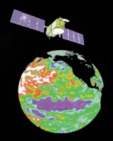
Pasadena - March 4, 2002 Following an in-depth performance review by NASA and the French Centre National d'Etudes Spatiales, the Jason 1 oceanography satellite has been declared ready for operational service. With the initiation of its operations phase, Jason has begun to generate its first science products on its mission to monitor global climate interactions between the sea and the atmosphere. Initial maps of sea-level anomalies, significant wave height and ocean wind speed confirm the health of the spacecraft science instruments and the mission's ability to meet its data turnaround requirements. Team managers from the French Space Agency's Satellite Control Center in Toulouse, France, and NASA's Jet Propulsion Laboratory, Pasadena, Calif., report Jason's satellite, payload and ground segment are all functioning properly. This declaration paves the way for the start of the mission's scientific validation phase. "Our first assessments show a surprising level of accuracy, exceeding that of Jason's predecessor, Topex/Poseidon," said Dr. Lee-Lueng Fu, Jason project scientist at JPL. "The mission's ambitious goal of determining the satellite's altitude with one-centimeter (.39 inches) accuracy therefore appears within reach. The first altimetry products also show a close match with measurements acquired by Topex/Poseidon." Launched December 7, 2001, from Vandenberg Air Force Base, Calif., Jason will continue Topex/Poseidon's observations of ocean surface topography for monitoring world ocean circulation, studying interactions of the oceans and atmosphere, improving climate predictions and observing events like El Ni�o. The excellent results of Jason's on-orbit checkout mean the next phase of the mission can now begin. Science data will be distributed to the mission's science team, and work will begin to conduct a precise scientific assessment of product quality and to cross-calibrate Jason and Topex/Poseidon products. Following completion of this six- month scientific validation phase, science data products will be released to the public. Community Email This Article Comment On This Article Related Links SpaceDaily Search SpaceDaily Subscribe To SpaceDaily Express Earth Observation News - Suppiliers, Technology and Application
 New York NY (SPX) Jan 11, 2006
The importance of remotely sensed data and technologies to support natural disasters has prompted attention and action in Washington. New initiatives and legislation authorizing appropriations to the remote sensing industry will be discussed at Strategic Research Institute's U.S. Commercial Remote Sensing Industry conference, scheduled for February 9-10, 2006 in Washington D.C. |
|
| The content herein, unless otherwise known to be public domain, are Copyright 1995-2006 - SpaceDaily.AFP and UPI Wire Stories are copyright Agence France-Presse and United Press International. ESA PortalReports are copyright European Space Agency. All NASA sourced material is public domain. Additionalcopyrights may apply in whole or part to other bona fide parties. Advertising does not imply endorsement,agreement or approval of any opinions, statements or information provided by SpaceDaily on any Web page published or hosted by SpaceDaily. Privacy Statement |