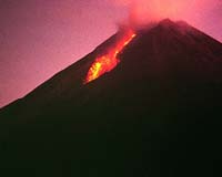
File photo: The unstable Mt Merapi, Indonesia.
File photo: The unstable Mt Merapi, Indonesia. |
Central Java Governor Mardiyanto said all districts on the slopes of the 2,914-metre (9,616-feet) volcano were preparing to coordinate relief and rescue efforts in the event of an eruption, the state Antara news agency reported. Villagers have set up early warning teams to monitor the volcano -- Indonesia's second most active -- around the clock, he added.
Triyani, from the Vulcanology office in Yogyakarta, told AFP that volcanic activity was fluctuating and although patterns had not changed greatly in the past weeks all the conditions for an eruption were present.
Central Java's social welfare office was preparing food parcels and shelter for anyone displaced. Local authorities have held several evacuation drills for villagers.
Local official Suryadi told Antara that prayer meetings were being held every night in many villages.
Detikcom online news service said villagers in Stabelan and Boyolali districts had lit torches and planted bamboo poles in front of their homes in a traditional ritual thought to appease the spirits of the volcano.
Merapi's last eruption in 1994 produced heat clouds which killed more than 60 people and forced 6,000 others to evacuate. The mountain last spewed smoke and lava in 2001 but no major eruption followed.
The volcano also erupted in 1976, killing 28 people and making 1,176 homeless.
President Susilo Bambang Yudhoyono warned on Sunday that Merapi could erupt anytime and called on residents to prepare themselves.
Indonesia sits on the "Pacific Rim of Fire" noted for its volcanic and seismic activity. The country has more than 100 active volcanoes.
Merapi's "stand-by" status is shared by Mount Karangetang on Siau island in the country's northernmost region.
"It still shows the same volcanic activities, with continuing shallow earthquakes," said geologist Toto Hendrasto, adding that the 1,784 meter volcano was given its "stand-by" status last year.
In an apparently unrelated incident a strong tectonic earthquake measuring 6.0 on the Richter scale hit the Mount Karangetang area early on Monday.
The quake was centered 200 kilometers (124 miles) under the seabed 116 kilometers north of Tahuna on Sangihe, an island north of Siau, the meteorology office said.
There were no immediate reports of damage or casualties.
Community
 Zrenjanin, Serbia-Montenegro (AFP) Apr 18, 2006
| The content herein, unless otherwise known to be public domain, are Copyright 1995-2006 - SpaceDaily.AFP and UPI Wire Stories are copyright Agence France-Presse and United Press International. ESA PortalReports are copyright European Space Agency. All NASA sourced material is public domain. Additionalcopyrights may apply in whole or part to other bona fide parties. Advertising does not imply endorsement,agreement or approval of any opinions, statements or information provided by SpaceDaily on any Web page published or hosted by SpaceDaily. Privacy Statement |