|
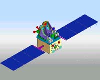
Sriharikota, India (AFP) May 02, 2005 An Indian space rocket is scheduled to blast off this week to put two satellites into orbit that will help the country's map makers and amateur radio operators, an official said Monday. The 44-metre (145-foot) Polar Satellite Launch Vehicle will lift-off Thursday and release a remote sensing satellite and one for home radio operators, project director N. Narayanamoorthy of the Indian Space Research Organization said. It would be the country's first effort to carry two satellites in a single launch, Narayanamoorthy said. The 1.5-ton Cartosat-1 will be released 18 minutes after the rocket takes off at 10:19 am (0449 GMT) Thursday, Narayanamoorthy said, adding that the smaller 42.5-kilogram (100-pound) HAMSAT will be put at a lower altitude. Cartosat-1 will be India's 11th remote-sensing satellite and is expected to provide high-resolution pictures to make more accurate maps, Narayanamoorthy said. "The two cameras in the satellite will have a swathe of 30 kilometresmiles) and are mounted in such a way that near simultaneous imaging of the same area from two angles is possible," he said. The communication satellite will provide ultra-high and very-high radio frequencies to broaden bandwidth which Indian home operators had been seeking for years, Narayanamoorthy said. Thursday's blast-off will be the second since last September when India launched a satellite to allow teachers to be broadcast to remote regions for primary and secondary education classes via television. Of the 135 transponders used for broadcasting India has in space, 11 are leased to the US-based firm Intelsat, bringing in 10 million dollars over a five-year period. Another 24 of the transponders are used by India's state-run television, with the rest mostly leased by private operators. Community Email This Article Comment On This Article Related Links SpaceDaily Search SpaceDaily Subscribe To SpaceDaily Express Earth Observation News - Suppiliers, Technology and Application
 New York NY (SPX) Jan 11, 2006
The importance of remotely sensed data and technologies to support natural disasters has prompted attention and action in Washington. New initiatives and legislation authorizing appropriations to the remote sensing industry will be discussed at Strategic Research Institute's U.S. Commercial Remote Sensing Industry conference, scheduled for February 9-10, 2006 in Washington D.C. |
|
| The content herein, unless otherwise known to be public domain, are Copyright 1995-2006 - SpaceDaily.AFP and UPI Wire Stories are copyright Agence France-Presse and United Press International. ESA PortalReports are copyright European Space Agency. All NASA sourced material is public domain. Additionalcopyrights may apply in whole or part to other bona fide parties. Advertising does not imply endorsement,agreement or approval of any opinions, statements or information provided by SpaceDaily on any Web page published or hosted by SpaceDaily. Privacy Statement |