|
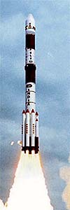
Sriharikota, India (AFP) May 05, 2005 An Indian rocket blasted off Thursday, carrying the country's ambitions to be a major global space power and two satellites that it launched into orbit. The liftoff in southeastern India marked the first time India has launched a rocket with two satellites aboard and notched up another achievement in its ambitious space programme to send a probe to the moon by 2007 or 2008. The launch "augments our launch capabilities considerably and reaffirms the emergence of India as a major space power," Prime Minister Manmohan Singh told parliament in New Delhi. The 44-metre (147-foot) Polar Satellite Launch Vehicle carried a remote sensing satellite whose detailed imaging is aimed at putting every Indian household on the map and another for South Asian home radio operators that can be used during disasters such as earthquakes and floods. The rocket lifted off from the Satish Dhawan space port, 100 kilometresmiles) north of Madras, to loud cheers from scientists and their families who watched the rocket streak into a clear blue sky. "It was a fantastically accurate flight and (satellite) injection," G. Madhavan Nair, chairman of the Bangalore-based Indian Space Research Organization (ISRO), told reporters. The satellites were placed into orbit soon after lift-off. President Abdul Kalam, a scientist dubbed India's "missile man" for his contribution to the country's satellite programmes, guided and ballistic missiles projects and nuclear weapons drive, watched the launch. "We are all proud of you," Kalam told scientists. Singh later sent a message to scientists at the space centre that "you are preparing India to take to the 21st century in terms of advancements in science and technology". It was the heaviest payload ever carried by the Polar Satellite Launch Vehicle, a version of which is planned for use by India's debut moon mission. On the launch's eve, space scientists placed tiny replicas of the rocket and the two satellites at a Hindu shrine and prayed for the mission's success. The biggest satellite, the 1.5-ton CARTOSAT-1, will supply high-resolution pictures for more precise maps for planning towns, laying new roads, digging canals, disaster assessment and water resources management. Among CARTOSAT's special features are two cameras that will provide stereo pictures to generate three-dimensional maps. Until now, Indian mapmakers have relied on combining satellite data to create three dimensional maps. The cameras are designed to read images smaller than a car by identifying features down to 2.5 metres (eight foot four inches) wide. The smaller 42.5-kilogram (94-pound) HAMSAT communications satellite will provide ultra-high and very-high radio frequencies to broaden bandwidth that Indian home operators had been seeking for years. India has grabbed headlines with its commitment to send a probe to the moon in two or three years time. But its space programme has mainly been aimed at harnessing high technology for its population of more than one billion, particularly its rural masses. The CARTOSAT-1 is India's 11th remote-sensing satellite on top of several broadcast satellites. India's other remote sensing satellites supply information for use in irrigation, agriculture and disaster management. India has the world's biggest civilian cluster of remote sensing satellites. Thursday's blast-off was the second since September when India launched Edusat, a distance learning satellite to allow teachers to broadcast primary and secondary classes to remote regions via television. Community Email This Article Comment On This Article Related Links SpaceDaily Search SpaceDaily Subscribe To SpaceDaily Express Earth Observation News - Suppiliers, Technology and Application
 New York NY (SPX) Jan 11, 2006
The importance of remotely sensed data and technologies to support natural disasters has prompted attention and action in Washington. New initiatives and legislation authorizing appropriations to the remote sensing industry will be discussed at Strategic Research Institute's U.S. Commercial Remote Sensing Industry conference, scheduled for February 9-10, 2006 in Washington D.C. |
|
| The content herein, unless otherwise known to be public domain, are Copyright 1995-2006 - SpaceDaily.AFP and UPI Wire Stories are copyright Agence France-Presse and United Press International. ESA PortalReports are copyright European Space Agency. All NASA sourced material is public domain. Additionalcopyrights may apply in whole or part to other bona fide parties. Advertising does not imply endorsement,agreement or approval of any opinions, statements or information provided by SpaceDaily on any Web page published or hosted by SpaceDaily. Privacy Statement |