|
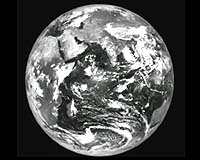
Bangalore - Sep 19, 2002 The Very High Resolution Radiometer (VHRR) on board India's first exclusive meteorological satellite, METSAT, was successfully switched on from Master Control Facility, Hassan at 12:45 hours yesterday (September 19, 2002 [0745 UTC]). The earth image in the Visible spectral band was taken in full- frame mode, which covers the full earth disc and the adjoining deep space. The earth imaging in Water Vapour and Infra-red spectral bands were commanded at 08:15 and 09:00 hours respectively today (September 20, 2002 [0315 UTC and 0400 UTC]). The images taken in the Visible, Water Vapour and Thermal Infra-red spectral bands received at Master Control Facility, Hassan are of excellent quality. VHRR on board METSAT has the capability to take images of earth in three spectral bands, -- Visible, Water Vapour and Thermal Infra-Red. The pictures provide a spatial resolution of 2 km x 2 km in Visible band and 8 km x 8 km in Water Vapour and thermal Infra-red bands. In addition to VHRR, the METSAT carries a Data Relay Transponder (DRT) configured to collect local meteorological information from unattended data collection platforms and relay them to Meteorological Data Utilisation Centre at New Delhi. It may be recalled that METSAT was launched by Polar Satellite Launch Vehicle, PSLV-C4, from Satish Dhawan Space Center, SHAR on September 12, 2002. Following the successful launch, orbit raising manoeuvres were conducted and the spacecraft was placed in the near Geo-Synchronous Orbit (GSO). It is now moving towards its intended orbital slot of 74 deg East longitude as per the plans. The 3-axis stabilisation of the spacecraft was carried out on September 16, 2002. The drift arresting manoeuvres were started yesterday from MCF, Hassan and the spacecraft is expected to be positioned in its designated orbital slot of 74 degree East on September 24, 2002. The detailed In-Orbit Testing (IOT) of the payload will start from September 23, 2002 and operational meteorological services from METSAT are expected to commence from the first week of October 2002. Community Email This Article Comment On This Article Related Links Indian Space Research Organisation SpaceDaily Search SpaceDaily Subscribe To SpaceDaily Express Earth Observation News - Suppiliers, Technology and Application
 New York NY (SPX) Jan 11, 2006
The importance of remotely sensed data and technologies to support natural disasters has prompted attention and action in Washington. New initiatives and legislation authorizing appropriations to the remote sensing industry will be discussed at Strategic Research Institute's U.S. Commercial Remote Sensing Industry conference, scheduled for February 9-10, 2006 in Washington D.C. |
|
| The content herein, unless otherwise known to be public domain, are Copyright 1995-2006 - SpaceDaily.AFP and UPI Wire Stories are copyright Agence France-Presse and United Press International. ESA PortalReports are copyright European Space Agency. All NASA sourced material is public domain. Additionalcopyrights may apply in whole or part to other bona fide parties. Advertising does not imply endorsement,agreement or approval of any opinions, statements or information provided by SpaceDaily on any Web page published or hosted by SpaceDaily. Privacy Statement |