|
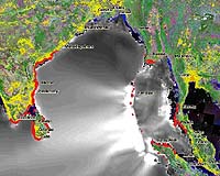
Longmont CO (SPX) Feb 08, 2005 DigitalGlobe has announced that ImageCat is using DigitalGlobe's QuickBird satellite imagery to assess damage resulting from the massive Indian Ocean tsunami that was triggered by an earthquake on Dec. 26, killing more than 226,000 people. On Jan. 7, ImageCat and the Multidisciplinary Center for Earthquake Engineering Research (MCEER) traveled to Phuket, Thailand with engineers from Japan's Chiba University and Bangkok's Asian Institute of Technology to document and analyze the tsunami damage. In Thailand, more than 5,300 people were killed, important tourist destinations were devastated, and the shrimp industry suffered US$500 million in damage. The team deployed ImageCat's custom-built Visualizing Impacts of Earthquakes with Satellites (VIEWS), a portable notebook-based reconnaissance system that links high-resolution QuickBird imagery, digital photographs and digital video footage to a real-time GPS feed. The team used 60-centimeter QuickBird imagery collected over Patong Beach in Phuket on Jan. 2, 2005, and for comparison purposes, imagery collected in March 2002. VIEWS is operated with a digital video recorder and digital camera from either a moving vehicle or on-foot, and produces a permanent visual record of damage. "QuickBird imagery helped identify key landmarks so that we could orient ourselves and navigate the area," said ImageCat's Shubharoop Ghosh, transportation systems analyst, who joined Japan's Professor Fumio Yamazaki and Thailand's Dr. Pennung Warnitchai on the expedition. "By essentially freezing events in time, VIEWS and the imagery helped us reconstruct the site after we returned to our home offices," Ghosh added. A field report detailing ImageCat's findings is located at: https://mceer.buffalo.edu/research/tsunami/page1.asp. ImageCat has used QuickBird imagery and the MCEER-funded VIEWS extensively for evaluating disasters, including the Oct. 2004 earthquake in Niigata, Japan; Florida's Aug. 2004 Hurricane Charley and Sept. 2004 Hurricane Ivan; and the Dec. 2003 Bam, Iran earthquake. Community Email This Article Comment On This Article Related Links ImageCat DigitalGlobe SpaceDaily Search SpaceDaily Subscribe To SpaceDaily Express Bringing Order To A World Of Disasters A world of storm and tempest When the Earth Quakes
 Bangalore, India (SPX) Jan 11, 2006
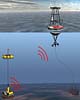
Indian Space Research Organisation is developing ocean bottom sensors that will help warn tsunami strikes in advance, the Press Trust Of India reports. |
|
| The content herein, unless otherwise known to be public domain, are Copyright 1995-2006 - SpaceDaily.AFP and UPI Wire Stories are copyright Agence France-Presse and United Press International. ESA PortalReports are copyright European Space Agency. All NASA sourced material is public domain. Additionalcopyrights may apply in whole or part to other bona fide parties. Advertising does not imply endorsement,agreement or approval of any opinions, statements or information provided by SpaceDaily on any Web page published or hosted by SpaceDaily. Privacy Statement |