 |
Greenbelt - Oct 1, 2001 Largely natural "ups and downs" in a weather system centered near Iceland have contributed to regional variations and an overall decrease in Arctic sea ice cover over the last twenty years, according to new NASA research. As this semi-permanent low-pressure system intensifies and weakens, it affects the amount of air (generally warm) being brought into the Arctic to the east of the low and the amount of air (generally cold) being swept out of the Arctic to the west. These changes in turn affect the amount of ice cover in the respective regions, adding to the effects of climate warming. Claire L. Parkinson of NASA's Goddard Space Flight Center in Greenbelt, Md., highlights the changes in Arctic sea ice and their possible connection to the Icelandic low-pressure system in a paper appearing in the most recent issue of Polar Geography. Parkinson plotted the extent of sea ice using satellite passive-microwave data from 1979 through 1999. Data were analyzed from the Nimbus 7 satellite and three satellites of the Defense Meteorological Satellite Program (DMSP). Results confirm an overall decline in Arctic ice extent that has been connected with climate warming, but also show regional differences that suggest there are other influences. The "Icelandic Low" is a key to bringing a greater or lesser amount of warm air into the Arctic depending on the intensity of the system, and is part of a larger weather pattern called the North Atlantic Oscillation (NAO). NAO is the name for changes in the difference of air pressure between the semi- permanent low-pressure system centered near Iceland (the Icelandic Low) and a semi-permanent high-pressure system centered near the Azores Islands (better known as the Bermuda-Azores High). On average, both of these systems are present all year; however, both are strongest in winter. When both the high and the low intensify and fluctuate in pressure relative to one another, they change the circulation of cold and warm air in the region. When the Icelandic Low is strong, it forces cold Arctic air southward to the area west of Iceland and Greenland, setting the stage for increasing sea ice cover in Baffin Bay, the Labrador Sea, Hudson Bay and the Gulf of St. Lawrence. At the same time, to the east, warm air that is swept northward reduces ice extent. This warmer air contributes to the reduced ice extents east and north of Greenland, and the reduced extent of ice in the entire Arctic overall. "When the Icelandic Low is weak, it will still bring warm air northward to the east of Iceland, but not as much as when the Icelandic Low is strong," Parkinson said.
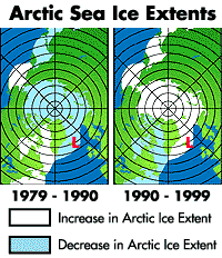
The strength of the Icelandic Low tended to increase from 1979 to 1990, then decrease in the 1990s. From 1979 to 1990 the ice cover to the east and north of the Low, in the Kara and Barents Seas and the Arctic Ocean, decreased, while the ice cover to the west of the Low, in Baffin Bay/Labrador Sea, Hudson Bay and the Gulf of St. Lawrence, increased. From 1990 to 1999 the situation was reversed, with the ice cover to the east and north of the Low increasing and the ice cover to the west of the Low decreasing. "This regional pattern of reversals in the ice extent trends is highly suggestive of an Icelandic Low impact, or, more broadly, of an impact from the North Atlantic Oscillation," Parkinson explained. "Still, the satellite data reveal an overall decrease in Arctic sea ice extent since 1978." The overall decrease in sea ice cover has generated questions about whether Arctic sea ice is being influenced by global warming. Parkinson urges caution in drawing conclusions for decreases in Arctic ice. "The trend of decreasing ice extent showed some signs of reversing in the 1990s," she noted. "Whether the ice cover as a whole will continue to exhibit the decreases that it experienced over the 1979 to 1999 period might depend on the strength and phase of the NAO, as well as on long-term trends in the climate system." Community Email This Article Comment On This Article Related Links SpaceDaily Search SpaceDaily Subscribe To SpaceDaily Express Dirt, rocks and all the stuff we stand on firmly
 Paris (ESA) Jan 12, 2006
Using the ESA Cluster spacecraft and the NASA Wind and ACE satellites, a team of American and European scientists have discovered the largest jets of particles created between the Earth and the Sun by magnetic reconnection. This result makes the cover of this week's issue of Nature. |
|
|
|
|
|
|
|
|
|
|
|
|
|
| The content herein, unless otherwise known to be public domain, are Copyright 1995-2006 - SpaceDaily.AFP and UPI Wire Stories are copyright Agence France-Presse and United Press International. ESA PortalReports are copyright European Space Agency. All NASA sourced material is public domain. Additionalcopyrights may apply in whole or part to other bona fide parties. Advertising does not imply endorsement,agreement or approval of any opinions, statements or information provided by SpaceDaily on any Web page published or hosted by SpaceDaily. Privacy Statement |
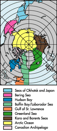 The study examined the ice in nine regions of Northern Hemisphere sea ice cover: the Arctic Ocean, the Kara and Barents Seas, the Greenland Sea, Baffin Bay/Labrador Sea, the Gulf of St. Lawrence, Hudson Bay, the Bering Sea, the Canadian Archipelago, and the Seas of Okhotsk and Japan.